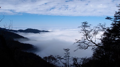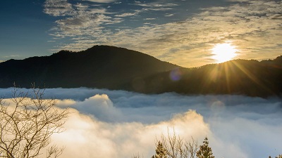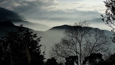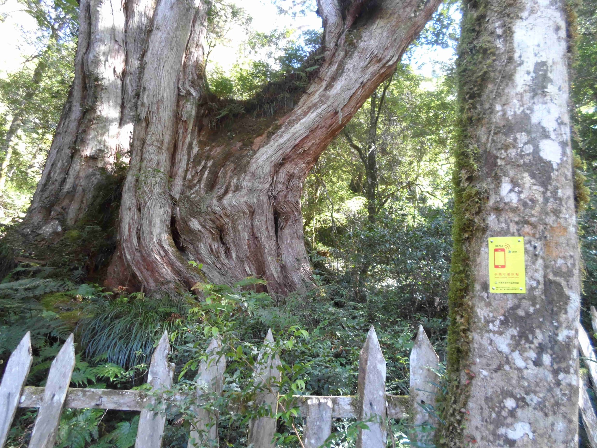
In Atayal, the Zhenxibao Settlement is called Cinsbu which means “The sun is already shining on the land while you’re still deep in sleep in early morning and will continue to shine until evening comes. Day is warm and night is cold; this is a land where disease and pests are extinct and crops grow well.” This land has nurtured the largest virgin Taiwan cypress forest in Taiwan, standing across the Takejin Creek from the Smangus Giant ancient trees. The forest extends eastward and connects with the Qilan virgin Taiwan cypress forest around Yuanyang Lake in Yilan. The giant trees were given names according to their shapes. The ones called Adam, Eve and Pregnant Mother are the most famous.
06/24 Wed.
Open
24°
21° / 28°
新竹縣 / 尖石鄉
More
Weather Forecast
|
06.25
Thur.
|
06.26
Fri.
|
06.27
Sat.
|
06.28
Sun.
|
06.29
Mon.
|
06.30
Tue.
|
07.01
Wed.
|
|
|---|---|---|---|---|---|---|---|
| Temperature |
21 ° / 28 °
|
21 ° / 24 °
|
21 ° / 25 °
|
21 ° / 27 °
|
21 ° / 28 °
|
21 ° / 29 °
|
21 ° / 29 °
|
| Feel like | 24 ° / 32 ° | 23 ° / 28 ° | 23 ° / 30 ° | 23 ° / 31 ° | 23 ° / 33 ° | 23 ° / 34 ° | 23 ° / 33 ° |
|
Probability of Precipitation |
70 % | 50 % | 100 % | - | - | - | - |
| Relative Humidity | 92 % | 97 % | 97 % | 95 % | 93 % | 90 % | 88 % |
|
Wind speed Wind direction |
2
W
|
2
NE
|
-
NE
|
2
SW
|
2
SW
|
2
S
|
2
SW
|
| UVI |
8
Very High
|
5
Moderate
|
6
High
|
7
High
|
9
Very High
|
8
Very High
|
8
Very High
|
|
Sunrise Sunset |
|
|
|
|
|
|
|
Central Weather Bureau|Update Time:2026/06/24 16:50
Jianshih Township, Hsinchu County
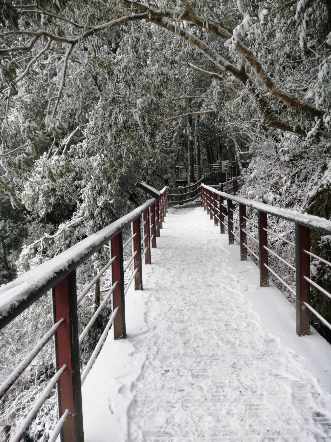
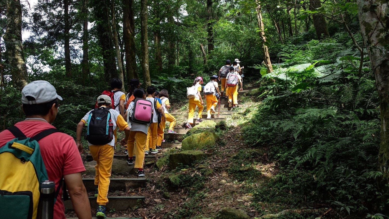
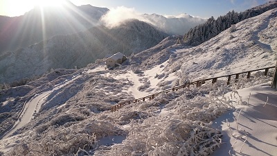
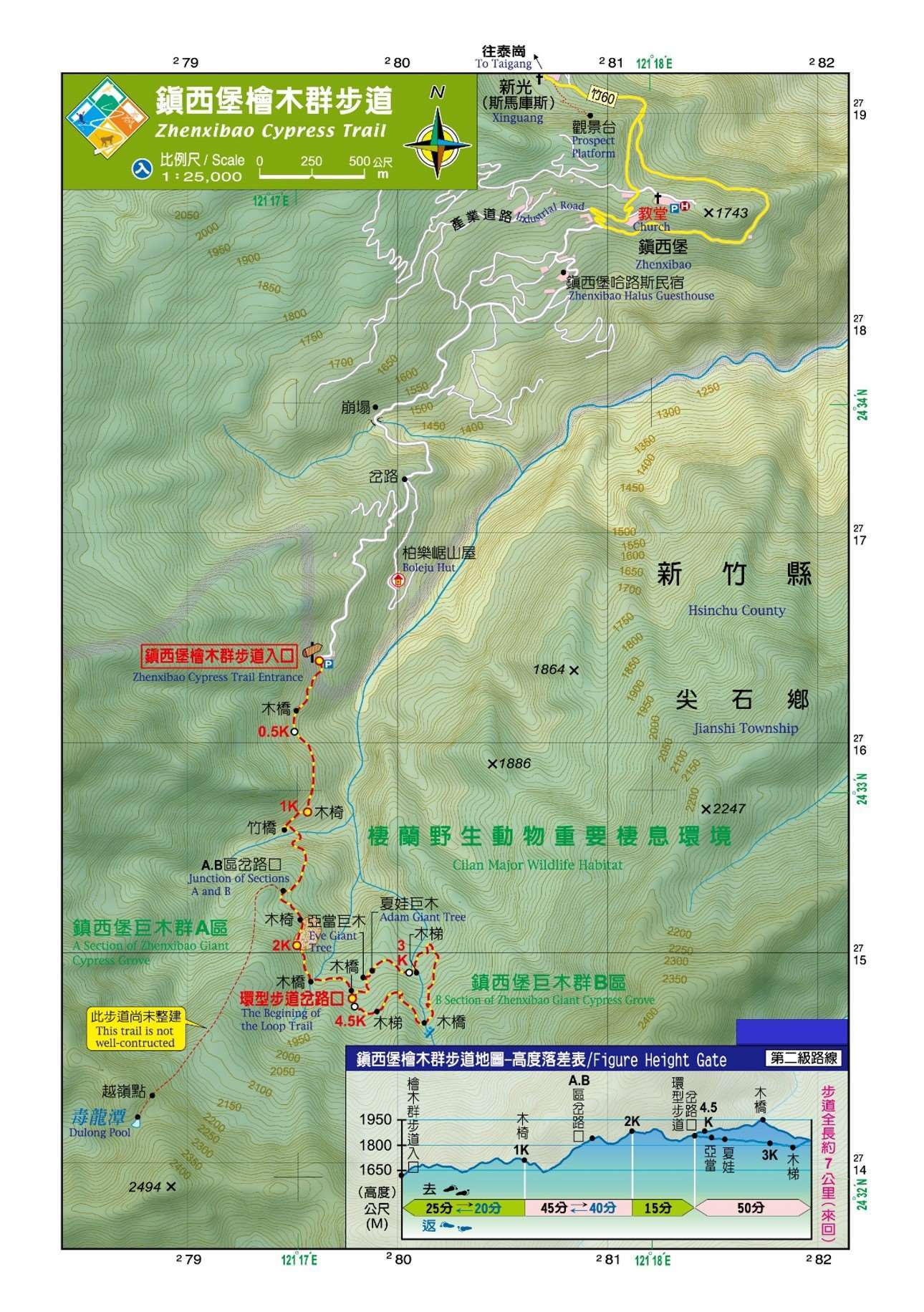
Zhenxibao Cypress Trail
Learn about the Trail
Trail difficulty level
| Hiking Level |
|
|
|
|
|
|
|
||||||||||||||||||||||||||||||||||||||||||
|---|---|---|---|---|---|---|---|---|---|---|---|---|---|---|---|---|---|---|---|---|---|---|---|---|---|---|---|---|---|---|---|---|---|---|---|---|---|---|---|---|---|---|---|---|---|---|---|---|---|
| Target | General Public | General Public | Those who have better physical energy | Beginner mountain climber with good physical energy and map literacy. | Open to those who have good physical strength, map reading skills, and wild survival skills. | Open to well-trained mountain climbers. | Open to well-trained mountain climbers. | ||||||||||||||||||||||||||||||||||||||||||
| Elevation | Gently sloping area | In recreational areas, close to settlements or about 1,000 meters above sea level. | In recreational areas, close to settlements or between 1,000~2,000 meters above sea level. | Remote areas or between 2,000 to 3,000 meters above sea level | Remote areas, wilderness, or between 2,000 to 3,000 meters above sea level | Remote areas, wilderness, or more than 3,000 meters above sea level | Remote areas, wilderness, or more than 3,000 meters above sea level | ||||||||||||||||||||||||||||||||||||||||||
| Required Time | It takes half to one day. | It takes half to one day. | It can be done within one day. | It takes one or more days. | Overnight preparation required. | It takes up to three days. | It takes up to three days. | ||||||||||||||||||||||||||||||||||||||||||
| Equipment | Light backpacking (water and small amount of food) | Light backpacking (water and small amount of food) | Light backpacking (water and proper amount of food) | Overnight preparation required. (e.g. drinking water, food, map, warm clothing, first-aid medicine, etc.) Application for entrance permission in advance is required if there is access control. | Comprehensive Mountaineering Gear Required. (e.g. food, drinking water, cooking utensils, map, warm clothing, flashlight, sleeping bag, tent, etc.) Application for entrance permission in advance is required if there is access control. | Comprehensive Mountaineering Gear Required. (e.g. food, drinking water, cooking utensils, map, warm clothing, flashlight, sleeping bag, tent, etc.) Application for entrance permission in advance is required if there is access control. | Comprehensive Mountaineering Gear Required. (e.g. food, drinking water, cooking utensils, map, warm clothing, flashlight, sleeping bag, tent, etc.) Application for entrance permission in advance is required if there is access control. | ||||||||||||||||||||||||||||||||||||||||||
| Description | Flat hiking trails. Relatively even slopes with comprehensive facilities and smooth road surface. Accessible for handicapped assistive devices or baby strollers. | An open hiking trail with easy access. Relatively even slopes with comprehensive facilities and smooth road surface. It takes half a day or less than one day to complete. | An open hiking trail with easy access. Somewhat steep slope with some difficult sections, but has comprehensive facilities and smooth road surface. It takes less than one day to complete. | A hiking trail locates at remote area or with part of the route is in area which requires entrance permission. Application in advance is required. Part of the route is in relatively bad condition with steeper slopes, but basic facilities are provided. It takes one day or between one to three days to complete. | A hiking trail locates at remote area or with part of the route is in area which requires entrance permission. It’s located in high-altitude areas (higher than 3000 meters above sea level). The trail is relatively primitive, with steeper slopes and unstable weather conditions. Part of the route may be dangerous or difficult for climbers. It takes two to three days to complete. Lead from professionals is recommended. | A hiking trail locates at area with inconvenient traffic, and mostly with routes in area which requires entrance permission. It’s located in high-altitude areas (higher than 3000 meters above sea level). The trail is located at primitive area, with bad condition, steeper slopes, and unstable weather conditions. Many parts of the route may be dangerous or difficult for climbers. It takes three or more days to complete. Lead from professionals is recommended. | 1. Level 3, 4 or 5 trails when snow or ice accumulating 2. Informal trails, without clear subgrades or paths, belong to special routes such as original mountain trails, ancient trail relics, prospecting, or technical climbing. |
Hiking Level
Target
General Public
Elevation
Gently sloping area
Required Time
It takes half to one day.
Equipment
Light backpacking (water and small amount of food)
Description
Flat hiking trails. Relatively even slopes with comprehensive facilities and smooth road surface. Accessible for handicapped assistive devices or baby strollers.
Hiking Level
Target
General Public
Elevation
In recreational areas, close to settlements or about 1,000 meters above sea level.
Required Time
It takes half to one day.
Equipment
Light backpacking (water and small amount of food)
Description
An open hiking trail with easy access. Relatively even slopes with comprehensive facilities and smooth road surface. It takes half a day or less than one day to complete.
Hiking Level
Target
Those who have better physical energy
Elevation
In recreational areas, close to settlements or between 1,000~2,000 meters above sea level.
Required Time
It can be done within one day.
Equipment
Light backpacking (water and proper amount of food)
Description
An open hiking trail with easy access. Somewhat steep slope with some difficult sections, but has comprehensive facilities and smooth road surface. It takes less than one day to complete.
Hiking Level
Target
Beginner mountain climber with good physical energy and map literacy.
Elevation
Remote areas or between 2,000 to 3,000 meters above sea level
Required Time
It takes one or more days.
Equipment
Overnight preparation required. (e.g. drinking water, food, map, warm clothing, first-aid medicine, etc.)
Application for entrance permission in advance is required if there is access control.
Description
A hiking trail locates at remote area or with part of the route is in area which requires entrance permission. Application in advance is required. Part of the route is in relatively bad condition with steeper slopes, but basic facilities are provided. It takes one day or between one to three days to complete.
Hiking Level
Target
Open to those who have good physical strength, map reading skills, and wild survival skills.
Elevation
Remote areas, wilderness, or between 2,000 to 3,000 meters above sea level
Required Time
Overnight preparation required.
Equipment
Comprehensive Mountaineering Gear Required. (e.g. food, drinking water, cooking utensils, map, warm clothing, flashlight, sleeping bag, tent, etc.)
Application for entrance permission in advance is required if there is access control.
Description
A hiking trail locates at remote area or with part of the route is in area which requires entrance permission. It’s located in high-altitude areas (higher than 3000 meters above sea level). The trail is relatively primitive, with steeper slopes and unstable weather conditions. Part of the route may be dangerous or difficult for climbers. It takes two to three days to complete. Lead from professionals is recommended.
Hiking Level
Target
Open to well-trained mountain climbers.
Elevation
Remote areas, wilderness, or more than 3,000 meters above sea level
Required Time
It takes up to three days.
Equipment
Comprehensive Mountaineering Gear Required. (e.g. food, drinking water, cooking utensils, map, warm clothing, flashlight, sleeping bag, tent, etc.)
Application for entrance permission in advance is required if there is access control.
Description
A hiking trail locates at area with inconvenient traffic, and mostly with routes in area which requires entrance permission. It’s located in high-altitude areas (higher than 3000 meters above sea level). The trail is located at primitive area, with bad condition, steeper slopes, and unstable weather conditions. Many parts of the route may be dangerous or difficult for climbers. It takes three or more days to complete. Lead from professionals is recommended.
Hiking Level
Target
Open to well-trained mountain climbers.
Elevation
Remote areas, wilderness, or more than 3,000 meters above sea level
Required Time
It takes up to three days.
Equipment
Comprehensive Mountaineering Gear Required. (e.g. food, drinking water, cooking utensils, map, warm clothing, flashlight, sleeping bag, tent, etc.)
Application for entrance permission in advance is required if there is access control.
Description
1. Level 3, 4 or 5 trails when snow or ice accumulating
2. Informal trails, without clear subgrades or paths, belong to special routes such as original mountain trails, ancient trail relics, prospecting, or technical climbing.
Reachable by Vehicle
X:Cars、Microbus、Coach Bus
Mountain system
-
Administer
Hsinchu Forest Dist. Office
Elevation
1,628 ~ 1,927 m
Service Line
+886 35224163 #262
Altitude Difference
299 m
Huts
-
Length of the Trail
4.6 KM
Entry Permit
No
Trail type
Partial Ring
Via Nature Reserve
No
Service Line
Primitive mountain trail
Geologically Sensitive Area
Yes
Route planning
1 day
Debris Flow Torrents
No
Trail Track
Trail route
Trailhead / Trig
Mobile coverage
Observations (From iNaturalist)
Trailhead / Trig
Mobile coverage
Observations (From iNaturalist)
Reminders
Travel with others and don’t take shortcuts
For your own safety, please travel with a group, follow the signs, do not take shortcuts or create your own route, and do not wander alone.
Carry GPS positioning system and communication equipment
Please plan your itinerary properly and bring enough equipment and food for hiking. It is recommended to bring a global satellite positioning system (GPS) and communication equipment such as satellite phones, mobile phones, radios or equipment with satellite positioning functions such as personal location trackers (PLBs), etc., and bring enough batteries to ensure emergency communication.
Pass through danger zones quickly
The road conditions in the mountains are unstable. Please do not stop or take photos in dangerous places such as landslides or rockfall areas, and pay attention to your own safety at all times.
It is recommended to purchase mountaineering insurance
Mountain activities have certain risks. It is recommended that you purchase mountaineering insurance before departure. (Note: General travel insurance does not necessarily cover mountaineering accidents. It is recommended to read the policy carefully before purchasing. For mountaineering insurance, please refer to the following press release of the Financial Supervisory Commission and choose the appropriate policy to purchase)
Mountaineering insurance sold by property and casualty insurance companies has expanded coverage to include search and rescue expenses
Please click the link below for content
Mountaineering safety information
For information on mountaineering safety knowledge, mountaineering equipment, map usage skills, etc., please see the mountaineering supply station webpage below. It is recommended to read it before the trip to ensure the safety of your outdoor activities.
Recommended Equipment
Zhenxibao Giant Trees Trail_Single-day mountaineering trail recommended equipment list
Mountain Encyclopedia
Please click below to view information
Travel Guide

Travel Guide
Nearby Attractions
Zhenxibao Tribe
The tribesmen work from sunrise to sunset and mainly grow temperate fruits such as plums, peaches, persimmons and summer vegetables. You can enjoy the tribal customs as the seasons change, including the cherry blossom season in February, the peach blossom festival in March, the peach season from July to August, the persimmon festival in October and the sacred tree festival in November.
Li Dongshan Castle
Lidong Mountain is 1913 meters high and has a first-class triangulation point foundation stone. It is located at the gateway connecting Hsinchu and Taoyuan's back mountains, and has strategic value. Since the Qing Dynasty, troops have been stationed there. During the Japanese occupation, a bunker was built on the top of the mountain, equipped with cannons to control the Atayal tribe. Now only ruins remain. From the top of the mountain, you can overlook the mid-level mountains in Taoyuan and Hsinchu, as well as the magnificent mountains of Da and Xiao Bajian.
Xiulan Tribe
The old name is "Kongxi". In Atayal language, it is called "Habun Tunan". "Habun" refers to the place where two rivers meet, hence the name "Kongxi". Surrounded by high mountains, the whole village is like a paradise in the valley. Luan Hot Spring is located in the river valley outside Xiuluan Village. It is a wild stream hot spring with excellent water quality. Due to the inconvenience of transportation, it has been seldom developed and has a primitive atmosphere.
Travel Advice
Arrange a 2-day itinerary. On the first day, visit and stay at Xinguang Village or Zhenxibao Village. On the second day, enter the Zhenxibao Cypress Group Trail early in the morning to enjoy the world-class red cypress giant tree group landscape.
Nearby Attractions