
Jianshih Township, Hsinchu County, Wufeng Township, Hsinchu County
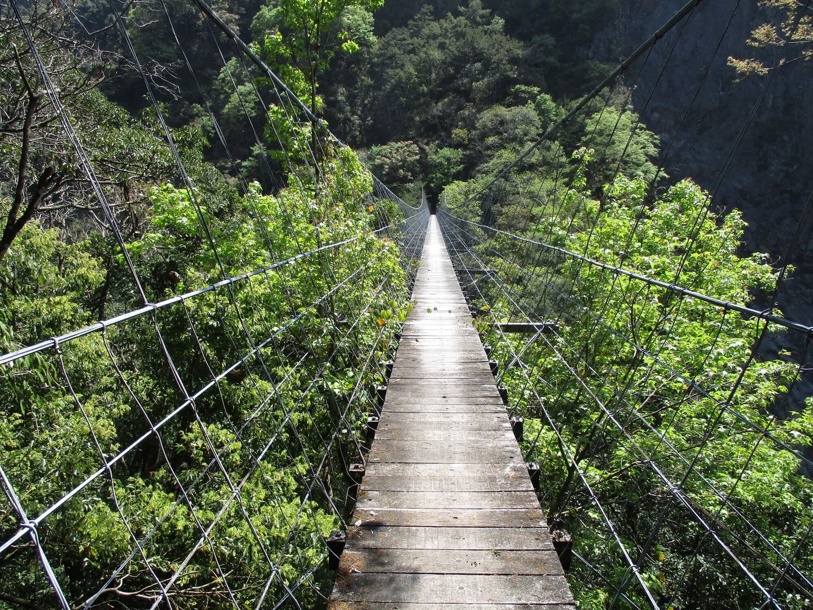
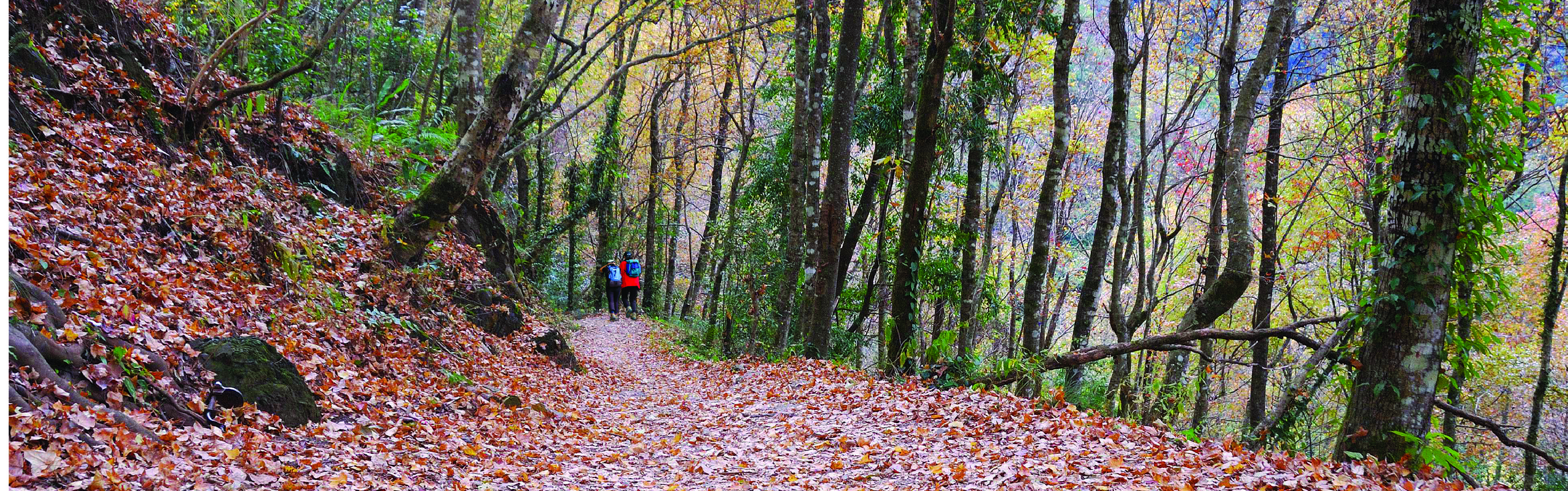
Xiakaluo National Trail
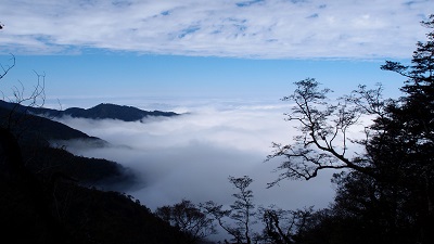
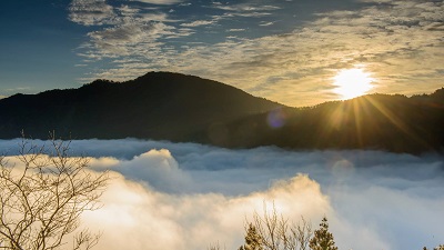
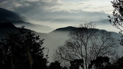
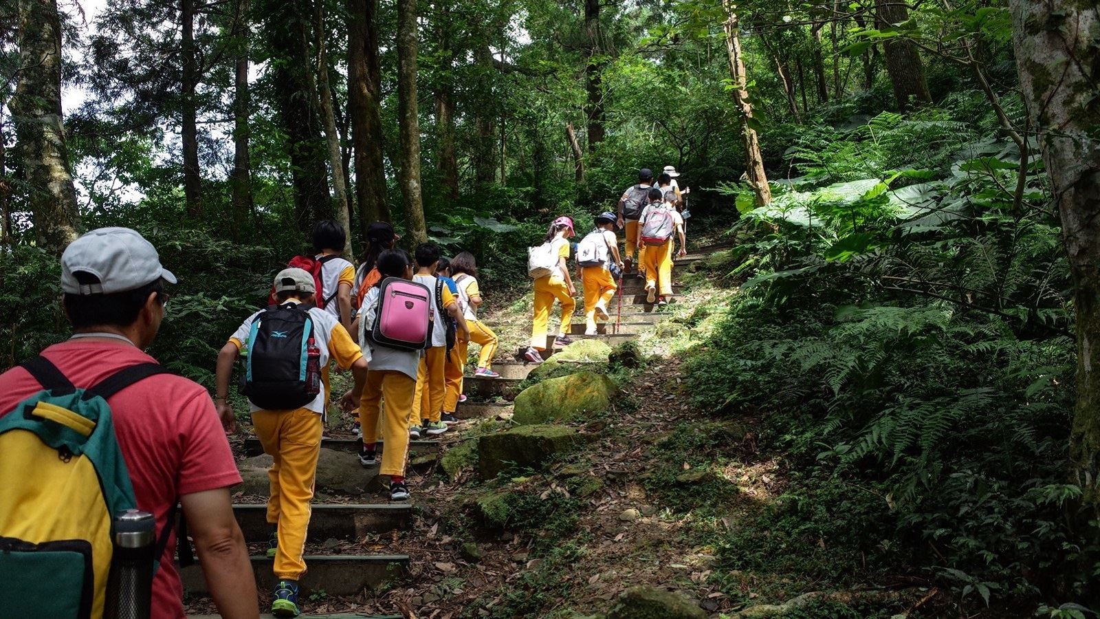
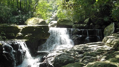
Xiakaluo is an Atayal word for Formosan Michelia and the trail got its name because there used to be a lot of Formosan Michelia trees. The ancient trail is between Wufeng Township and Jianshi Township in Hsinchu County. It was a major road for people in the local settlements to connect to the outside world. During the Japanese Rule, construction work was carried out to turn it into a police patrol road and artillery batteries and police stations were set up. Today, many ruins can still be seen. The trail runs through the upstream of Dahan River and crosses the Touqian Creek and the catchment area of Dahan River. The river valley is the result. Along the trail, there are a number of excellent spots for maple watching. In autumn, the entire hill is covered in red. It is a celebrated maple-watching location.
07/08 Wed.
Partially
26°
22° / 32°
新竹縣 / 尖石鄉
More
Weather Forecast
|
07.09
Thur.
|
07.10
Fri.
|
07.11
Sat.
|
07.12
Sun.
|
07.13
Mon.
|
07.14
Tue.
|
07.15
Wed.
|
|
|---|---|---|---|---|---|---|---|
| Temperature |
22 ° / 32 °
|
22 ° / 31 °
|
23 ° / 26 °
|
23 ° / 31 °
|
23 ° / 29 °
|
22 ° / 29 °
|
22 ° / 29 °
|
| Feel like | 24 ° / 37 ° | 24 ° / 35 ° | 19 ° / 30 ° | 26 ° / 36 ° | 25 ° / 34 ° | 24 ° / 34 ° | 25 ° / 35 ° |
|
Probability of Precipitation |
20 % | 100 % | 100 % | - | - | - | - |
| Relative Humidity | 86 % | 91 % | 96 % | 92 % | 94 % | 94 % | 94 % |
|
Wind speed Wind direction |
2
SW
|
4
NE
|
-
SW
|
-
SW
|
2
E
|
-
NE
|
-
NW
|
| UVI |
11
危險級
|
9
Very High
|
6
High
|
9
Very High
|
9
Very High
|
8
Very High
|
9
Very High
|
|
Sunrise Sunset |
|
|
|
|
|
|
|
Central Weather Bureau|Update Time:2026/07/08 17:02
Jianshih Township, Hsinchu County, Wufeng Township, Hsinchu County
Xiakaluo National Trail
Learn about the Trail
Application
Transportation
Starting from Qingquan
Take the Zhulin Interchange on National Highway 3 to the city of Zhudong, then follow County Road 122 to Qingquan in Wufeng Township, and continue along the Qingshi Industrial Road to the entrance of the Xiakaluo National Trail.
Starting from Yanglao
Take the 120 Township Road from the expressway to Neiwan, Hsinchu. Pass the Jianshi Township Office and turn onto the Jianshi Bridge. Continue onto Township Road 60 toward Xiulan. At Yulao, turn onto Xiulan (Jin) Road (Zhu 65) to Yanglao.
-
Trail difficulty level
| Hiking Level |
|
|
|
|
|
|
|
||||||||||||||||||||||||||||||||||||||||||
|---|---|---|---|---|---|---|---|---|---|---|---|---|---|---|---|---|---|---|---|---|---|---|---|---|---|---|---|---|---|---|---|---|---|---|---|---|---|---|---|---|---|---|---|---|---|---|---|---|---|
| Target | General Public | General Public | Those who have better physical energy | Beginner mountain climber with good physical energy and map literacy. | Open to those who have good physical strength, map reading skills, and wild survival skills. | Open to well-trained mountain climbers. | Open to well-trained mountain climbers. | ||||||||||||||||||||||||||||||||||||||||||
| Elevation | Gently sloping area | In recreational areas, close to settlements or about 1,000 meters above sea level. | In recreational areas, close to settlements or between 1,000~2,000 meters above sea level. | Remote areas or between 2,000 to 3,000 meters above sea level | Remote areas, wilderness, or between 2,000 to 3,000 meters above sea level | Remote areas, wilderness, or more than 3,000 meters above sea level | Remote areas, wilderness, or more than 3,000 meters above sea level | ||||||||||||||||||||||||||||||||||||||||||
| Required Time | It takes half to one day. | It takes half to one day. | It can be done within one day. | It takes one or more days. | Overnight preparation required. | It takes up to three days. | It takes up to three days. | ||||||||||||||||||||||||||||||||||||||||||
| Equipment | Light backpacking (water and small amount of food) | Light backpacking (water and small amount of food) | Light backpacking (water and proper amount of food) | Overnight preparation required. (e.g. drinking water, food, map, warm clothing, first-aid medicine, etc.) Application for entrance permission in advance is required if there is access control. | Comprehensive Mountaineering Gear Required. (e.g. food, drinking water, cooking utensils, map, warm clothing, flashlight, sleeping bag, tent, etc.) Application for entrance permission in advance is required if there is access control. | Comprehensive Mountaineering Gear Required. (e.g. food, drinking water, cooking utensils, map, warm clothing, flashlight, sleeping bag, tent, etc.) Application for entrance permission in advance is required if there is access control. | Comprehensive Mountaineering Gear Required. (e.g. food, drinking water, cooking utensils, map, warm clothing, flashlight, sleeping bag, tent, etc.) Application for entrance permission in advance is required if there is access control. | ||||||||||||||||||||||||||||||||||||||||||
| Description | Flat hiking trails. Relatively even slopes with comprehensive facilities and smooth road surface. Accessible for handicapped assistive devices or baby strollers. | An open hiking trail with easy access. Relatively even slopes with comprehensive facilities and smooth road surface. It takes half a day or less than one day to complete. | An open hiking trail with easy access. Somewhat steep slope with some difficult sections, but has comprehensive facilities and smooth road surface. It takes less than one day to complete. | A hiking trail locates at remote area or with part of the route is in area which requires entrance permission. Application in advance is required. Part of the route is in relatively bad condition with steeper slopes, but basic facilities are provided. It takes one day or between one to three days to complete. | A hiking trail locates at remote area or with part of the route is in area which requires entrance permission. It’s located in high-altitude areas (higher than 3000 meters above sea level). The trail is relatively primitive, with steeper slopes and unstable weather conditions. Part of the route may be dangerous or difficult for climbers. It takes two to three days to complete. Lead from professionals is recommended. | A hiking trail locates at area with inconvenient traffic, and mostly with routes in area which requires entrance permission. It’s located in high-altitude areas (higher than 3000 meters above sea level). The trail is located at primitive area, with bad condition, steeper slopes, and unstable weather conditions. Many parts of the route may be dangerous or difficult for climbers. It takes three or more days to complete. Lead from professionals is recommended. | 1. Level 3, 4 or 5 trails when snow or ice accumulating 2. Informal trails, without clear subgrades or paths, belong to special routes such as original mountain trails, ancient trail relics, prospecting, or technical climbing. |
Hiking Level
Target
General Public
Elevation
Gently sloping area
Required Time
It takes half to one day.
Equipment
Light backpacking (water and small amount of food)
Description
Flat hiking trails. Relatively even slopes with comprehensive facilities and smooth road surface. Accessible for handicapped assistive devices or baby strollers.
Hiking Level
Target
General Public
Elevation
In recreational areas, close to settlements or about 1,000 meters above sea level.
Required Time
It takes half to one day.
Equipment
Light backpacking (water and small amount of food)
Description
An open hiking trail with easy access. Relatively even slopes with comprehensive facilities and smooth road surface. It takes half a day or less than one day to complete.
Hiking Level
Target
Those who have better physical energy
Elevation
In recreational areas, close to settlements or between 1,000~2,000 meters above sea level.
Required Time
It can be done within one day.
Equipment
Light backpacking (water and proper amount of food)
Description
An open hiking trail with easy access. Somewhat steep slope with some difficult sections, but has comprehensive facilities and smooth road surface. It takes less than one day to complete.
Hiking Level
Target
Beginner mountain climber with good physical energy and map literacy.
Elevation
Remote areas or between 2,000 to 3,000 meters above sea level
Required Time
It takes one or more days.
Equipment
Overnight preparation required. (e.g. drinking water, food, map, warm clothing, first-aid medicine, etc.)
Application for entrance permission in advance is required if there is access control.
Description
A hiking trail locates at remote area or with part of the route is in area which requires entrance permission. Application in advance is required. Part of the route is in relatively bad condition with steeper slopes, but basic facilities are provided. It takes one day or between one to three days to complete.
Hiking Level
Target
Open to those who have good physical strength, map reading skills, and wild survival skills.
Elevation
Remote areas, wilderness, or between 2,000 to 3,000 meters above sea level
Required Time
Overnight preparation required.
Equipment
Comprehensive Mountaineering Gear Required. (e.g. food, drinking water, cooking utensils, map, warm clothing, flashlight, sleeping bag, tent, etc.)
Application for entrance permission in advance is required if there is access control.
Description
A hiking trail locates at remote area or with part of the route is in area which requires entrance permission. It’s located in high-altitude areas (higher than 3000 meters above sea level). The trail is relatively primitive, with steeper slopes and unstable weather conditions. Part of the route may be dangerous or difficult for climbers. It takes two to three days to complete. Lead from professionals is recommended.
Hiking Level
Target
Open to well-trained mountain climbers.
Elevation
Remote areas, wilderness, or more than 3,000 meters above sea level
Required Time
It takes up to three days.
Equipment
Comprehensive Mountaineering Gear Required. (e.g. food, drinking water, cooking utensils, map, warm clothing, flashlight, sleeping bag, tent, etc.)
Application for entrance permission in advance is required if there is access control.
Description
A hiking trail locates at area with inconvenient traffic, and mostly with routes in area which requires entrance permission. It’s located in high-altitude areas (higher than 3000 meters above sea level). The trail is located at primitive area, with bad condition, steeper slopes, and unstable weather conditions. Many parts of the route may be dangerous or difficult for climbers. It takes three or more days to complete. Lead from professionals is recommended.
Hiking Level
Target
Open to well-trained mountain climbers.
Elevation
Remote areas, wilderness, or more than 3,000 meters above sea level
Required Time
It takes up to three days.
Equipment
Comprehensive Mountaineering Gear Required. (e.g. food, drinking water, cooking utensils, map, warm clothing, flashlight, sleeping bag, tent, etc.)
Application for entrance permission in advance is required if there is access control.
Description
1. Level 3, 4 or 5 trails when snow or ice accumulating
2. Informal trails, without clear subgrades or paths, belong to special routes such as original mountain trails, ancient trail relics, prospecting, or technical climbing.
Reachable by Vehicle
O:Cars , X:Microbus、Coach Bus
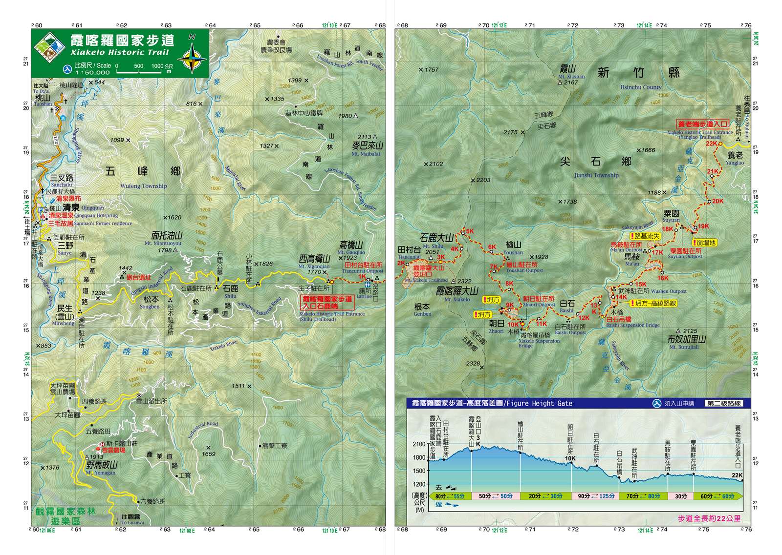
Mountain system
Xiakelo-Luchanglienling National Trail System
Administer
Hsinchu Forest Dist. Office
Elevation
1,600 ~ 1,900 m
Service Line
+886 35224163 #262
Altitude Difference
300 m
Huts
-
Length of the Trail
22 KM
Entry Permit
No
Trail type
Ring
Via Nature Reserve
No
Service Line
Primitive mountain trail
Geologically Sensitive Area
Yes
Route planning
1 day
Debris Flow Torrents
No
Trail Track
Trail route
Trailhead / Trig
Mobile coverage
Observations (From iNaturalist)
Trailhead / Trig
Mobile coverage
Observations (From iNaturalist)
Reminders
Travel with others and don’t take shortcuts
For your own safety, please travel with a group, follow the signs, do not take shortcuts or create your own route, and do not wander alone.
Carry GPS positioning system and communication equipment
Please plan your itinerary properly and bring enough equipment and food for hiking. It is recommended to bring a global satellite positioning system (GPS) and communication equipment such as satellite phones, mobile phones, radios or equipment with satellite positioning functions such as personal location trackers (PLBs), etc., and bring enough batteries to ensure emergency communication.
Pass through dangerous places quickly
The road conditions in the mountains are unstable. Please do not stop or take photos in dangerous places such as landslides or rockfall areas, and pay attention to your own safety at all times.
It is recommended to purchase mountaineering insurance
Mountain activities have certain risks. It is recommended that you purchase mountaineering insurance before departure. (Note: General travel insurance does not necessarily cover mountaineering accidents. It is recommended to read the policy carefully before purchasing. For mountaineering insurance, please refer to the following press release of the Financial Supervisory Commission and choose the appropriate policy to purchase)
Mountaineering insurance sold by property and casualty insurance companies has expanded coverage to include search and rescue expenses
Please click the link below for content
Mountaineering safety information
For information on mountaineering safety knowledge, mountaineering equipment, map usage skills, etc., please see the mountaineering supply station webpage below. It is recommended to read it before the trip to ensure the safety of your outdoor activities.
Low-rider cars are not recommended to go to the trailhead
The access road to the trail entrance is not suitable for vehicles with low chassis
Xiakaluo National Trail Ecological Tourism Guide Information
Xiakaluo Trail Facebook Fan Page
Please cooperate with the management around the Shiraishi Station
Camping sites have been set up around the Baishi Station for management. Some camping sites are reserved for self-organized tourists every day. Please do not camp, discard garbage or pile up items in the station building. The simple toilet is a dry toilet. Please take the garbage back. Keeping the natural environment clean is everyone's common responsibility.
Ecotourism Tour Information
Xiakara Tour Information and Contact Information
Recommended Equipment
Xiakaluo Ancient Trail_Suggested Equipment List for Multi-Day Hiking Trails
Mountain Encyclopedia
Please click below to view information
Travel Guide

Travel Guide
Nearby Attractions
Qingquan Tribe
It is a tribe of the Atayal people. Because of the hot springs gushing out of the valley, the Atayal people called it "ulay-mkilix". During the Japanese colonial period, the Japanese developed the hot springs and renamed it Inoue. It was once one of the eight scenic spots in Hsinchu. It was renamed Qingquan after Taiwan's restoration. The writer Sanmao once rented a house in Qingquan and named it "Dream House". The house still exists today. The "Inoue Hot Spring Sanatorium" where Zhang Xueliang was imprisoned has been washed away by typhoon landslides.
Xiulan Tribe
Xiuluan was formerly known as "Kongxi" and is called "Habun Tunan" in Atayal language. "Habun" refers to the place where two rivers meet, hence the name "Kongxi". Surrounded by high mountains, the entire village is like a paradise in the valley. Luan Hot Spring is located in the river valley outside Xiuluan Village. It is a wild stream hot spring with excellent water quality. Due to the inconvenience of transportation, it has been seldom developed and has a primitive atmosphere.
Travel Advice
Arrange a 2-3 day trip. Stay at Qingquan or Xiuluan Tribe on the first day, and enter the Xiakaluo National Trail from the Shilu Trailhead or Yanglao Trail the next day. You need to arrange a vehicle to complete the entire journey. Or arrange a 3-day tour with Wufeng Qingquan District.
Hsinchu Branch signs a memorandum of cooperation with cooperative groups
The Hsinchu Branch Office, the "Hsinchu County Wufeng Township Aboriginal Mountain Development Association" (East Line Group Bear Team) and the "New Taipei City Forest Recreation Association" (Liang Daba Mountain Service Team) jointly signed a one-year "Xiakaluo National Trail Joint Maintenance" memorandum of cooperation, with public and private sectors working together to maintain the ancient trail.
Nearby Attractions