
Heping District, Taichung City
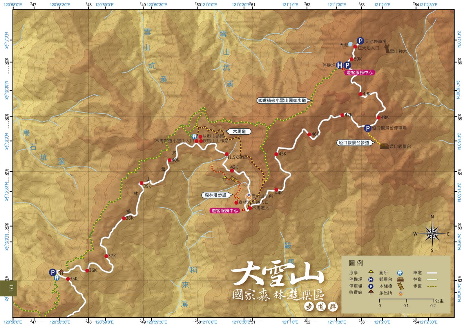
Dasyueshan National Forest Recreation Area Trails
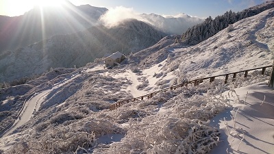
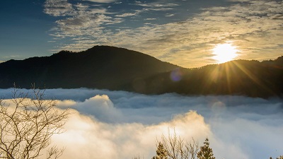
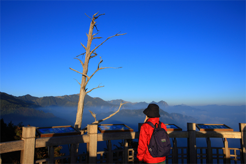
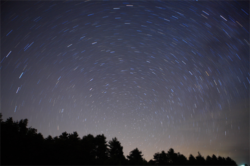
During the Japanese Rule, the Dasyueshan National Forest Recreation Area was an important lumber yard in central Taiwan. Accordingly, the scenery of the grassland was similar to the scenery around Daisetsuzan (Big Snow Mountain) in Hokkaido; therefore, the Japanese named it Daxueshan (Big Snow Mountain). Setting out from Dongshi and traveling up Daxueshan Forest Road, one can see obvious changes in forest physiognomy as a result of altitude variation: from broadleaf forests to mixed conifer-broadleaf forests and to conifer forests. Since the area is in the cloud forest belt, the weather is changeful. The administration of the recreation area has designed several trails and each of them has its unique features in different seasons, such as high mountain flowers in spring and summer and leaf color changes in autumn and winter. This is also the best spot for star gazing.
07/01 Wed.
Open
27°
23° / 31°
臺中市 / 和平區
More
Weather Forecast
|
07.01
Today
|
07.02
Thur.
|
07.03
Fri.
|
07.04
Sat.
|
07.05
Sun.
|
07.06
Mon.
|
07.07
Tue.
|
|
|---|---|---|---|---|---|---|---|
| Temperature |
23 ° / 31 °
|
22 ° / 32 °
|
22 ° / 32 °
|
22 ° / 32 °
|
22 ° / 30 °
|
22 ° / 32 °
|
22 ° / 30 °
|
| Feel like | 26 ° / 35 ° | 24 ° / 36 ° | 24 ° / 36 ° | 24 ° / 37 ° | 24 ° / 34 ° | 24 ° / 35 ° | 24 ° / 34 ° |
|
Probability of Precipitation |
20 % | 10 % | 10 % | - | - | - | - |
| Relative Humidity | 87 % | 87 % | 88 % | 89 % | 88 % | 85 % | 86 % |
|
Wind speed Wind direction |
2
NW
|
2
NE
|
2
NE
|
2
E
|
2
SW
|
2
SW
|
2
S
|
| UVI |
10
Very High
|
11
危險級
|
11
危險級
|
11
危險級
|
10
Very High
|
10
Very High
|
10
Very High
|
|
Sunrise Sunset |
|
|
|
|
|
|
|
Central Weather Bureau|Update Time:2026/07/01 11:21
Heping District, Taichung City
Dasyueshan National Forest Recreation Area Trails
Learn about the Trail
Application
Transportation
Driving
National highway no.1 or no.3→take National Highway no.4 to the end→Turn left to Provincial Highway no.3 to Tungshih→Cross Tung shih bridge, turn right, and go along Provincial highway no. 8→take the intersection to Dasyueshan200 forest trail to the right of Shuan chi Station of Tung Shih Forestry Bureau on Tung Guan Rd., or enter through Fng Shi Rd. and turn left to Tung Keng Rd,→Dasyueshan200 forest trail
By bus
Take Fengyuan Bus on Saturdays and Sundays (Provincial Highway -Big Snow Mountain)Provincial Highway Interval 08:00→Fengyuan Station 09:00→Tong Shih 09:30→Big Snow Mountain 11:00→Tian Chih Shenmu 13:00→Big Snow Mountain 14:30→Tong Shih Station 16:00→Fengyuan Station 16:30→Provincial Highway Interval 17:20(Provincial Highway Interval tel: 04-22877732; Fengyuan Station tel: 04-25246603)
Trail difficulty level
| Hiking Level |
|
|
|
|
|
|
|
||||||||||||||||||||||||||||||||||||||||||
|---|---|---|---|---|---|---|---|---|---|---|---|---|---|---|---|---|---|---|---|---|---|---|---|---|---|---|---|---|---|---|---|---|---|---|---|---|---|---|---|---|---|---|---|---|---|---|---|---|---|
| Target | General Public | General Public | Those who have better physical energy | Beginner mountain climber with good physical energy and map literacy. | Open to those who have good physical strength, map reading skills, and wild survival skills. | Open to well-trained mountain climbers. | Open to well-trained mountain climbers. | ||||||||||||||||||||||||||||||||||||||||||
| Elevation | Gently sloping area | In recreational areas, close to settlements or about 1,000 meters above sea level. | In recreational areas, close to settlements or between 1,000~2,000 meters above sea level. | Remote areas or between 2,000 to 3,000 meters above sea level | Remote areas, wilderness, or between 2,000 to 3,000 meters above sea level | Remote areas, wilderness, or more than 3,000 meters above sea level | Remote areas, wilderness, or more than 3,000 meters above sea level | ||||||||||||||||||||||||||||||||||||||||||
| Required Time | It takes half to one day. | It takes half to one day. | It can be done within one day. | It takes one or more days. | Overnight preparation required. | It takes up to three days. | It takes up to three days. | ||||||||||||||||||||||||||||||||||||||||||
| Equipment | Light backpacking (water and small amount of food) | Light backpacking (water and small amount of food) | Light backpacking (water and proper amount of food) | Overnight preparation required. (e.g. drinking water, food, map, warm clothing, first-aid medicine, etc.) Application for entrance permission in advance is required if there is access control. | Comprehensive Mountaineering Gear Required. (e.g. food, drinking water, cooking utensils, map, warm clothing, flashlight, sleeping bag, tent, etc.) Application for entrance permission in advance is required if there is access control. | Comprehensive Mountaineering Gear Required. (e.g. food, drinking water, cooking utensils, map, warm clothing, flashlight, sleeping bag, tent, etc.) Application for entrance permission in advance is required if there is access control. | Comprehensive Mountaineering Gear Required. (e.g. food, drinking water, cooking utensils, map, warm clothing, flashlight, sleeping bag, tent, etc.) Application for entrance permission in advance is required if there is access control. | ||||||||||||||||||||||||||||||||||||||||||
| Description | Flat hiking trails. Relatively even slopes with comprehensive facilities and smooth road surface. Accessible for handicapped assistive devices or baby strollers. | An open hiking trail with easy access. Relatively even slopes with comprehensive facilities and smooth road surface. It takes half a day or less than one day to complete. | An open hiking trail with easy access. Somewhat steep slope with some difficult sections, but has comprehensive facilities and smooth road surface. It takes less than one day to complete. | A hiking trail locates at remote area or with part of the route is in area which requires entrance permission. Application in advance is required. Part of the route is in relatively bad condition with steeper slopes, but basic facilities are provided. It takes one day or between one to three days to complete. | A hiking trail locates at remote area or with part of the route is in area which requires entrance permission. It’s located in high-altitude areas (higher than 3000 meters above sea level). The trail is relatively primitive, with steeper slopes and unstable weather conditions. Part of the route may be dangerous or difficult for climbers. It takes two to three days to complete. Lead from professionals is recommended. | A hiking trail locates at area with inconvenient traffic, and mostly with routes in area which requires entrance permission. It’s located in high-altitude areas (higher than 3000 meters above sea level). The trail is located at primitive area, with bad condition, steeper slopes, and unstable weather conditions. Many parts of the route may be dangerous or difficult for climbers. It takes three or more days to complete. Lead from professionals is recommended. | 1. Level 3, 4 or 5 trails when snow or ice accumulating 2. Informal trails, without clear subgrades or paths, belong to special routes such as original mountain trails, ancient trail relics, prospecting, or technical climbing. |
Hiking Level
Target
General Public
Elevation
Gently sloping area
Required Time
It takes half to one day.
Equipment
Light backpacking (water and small amount of food)
Description
Flat hiking trails. Relatively even slopes with comprehensive facilities and smooth road surface. Accessible for handicapped assistive devices or baby strollers.
Hiking Level
Target
General Public
Elevation
In recreational areas, close to settlements or about 1,000 meters above sea level.
Required Time
It takes half to one day.
Equipment
Light backpacking (water and small amount of food)
Description
An open hiking trail with easy access. Relatively even slopes with comprehensive facilities and smooth road surface. It takes half a day or less than one day to complete.
Hiking Level
Target
Those who have better physical energy
Elevation
In recreational areas, close to settlements or between 1,000~2,000 meters above sea level.
Required Time
It can be done within one day.
Equipment
Light backpacking (water and proper amount of food)
Description
An open hiking trail with easy access. Somewhat steep slope with some difficult sections, but has comprehensive facilities and smooth road surface. It takes less than one day to complete.
Hiking Level
Target
Beginner mountain climber with good physical energy and map literacy.
Elevation
Remote areas or between 2,000 to 3,000 meters above sea level
Required Time
It takes one or more days.
Equipment
Overnight preparation required. (e.g. drinking water, food, map, warm clothing, first-aid medicine, etc.)
Application for entrance permission in advance is required if there is access control.
Description
A hiking trail locates at remote area or with part of the route is in area which requires entrance permission. Application in advance is required. Part of the route is in relatively bad condition with steeper slopes, but basic facilities are provided. It takes one day or between one to three days to complete.
Hiking Level
Target
Open to those who have good physical strength, map reading skills, and wild survival skills.
Elevation
Remote areas, wilderness, or between 2,000 to 3,000 meters above sea level
Required Time
Overnight preparation required.
Equipment
Comprehensive Mountaineering Gear Required. (e.g. food, drinking water, cooking utensils, map, warm clothing, flashlight, sleeping bag, tent, etc.)
Application for entrance permission in advance is required if there is access control.
Description
A hiking trail locates at remote area or with part of the route is in area which requires entrance permission. It’s located in high-altitude areas (higher than 3000 meters above sea level). The trail is relatively primitive, with steeper slopes and unstable weather conditions. Part of the route may be dangerous or difficult for climbers. It takes two to three days to complete. Lead from professionals is recommended.
Hiking Level
Target
Open to well-trained mountain climbers.
Elevation
Remote areas, wilderness, or more than 3,000 meters above sea level
Required Time
It takes up to three days.
Equipment
Comprehensive Mountaineering Gear Required. (e.g. food, drinking water, cooking utensils, map, warm clothing, flashlight, sleeping bag, tent, etc.)
Application for entrance permission in advance is required if there is access control.
Description
A hiking trail locates at area with inconvenient traffic, and mostly with routes in area which requires entrance permission. It’s located in high-altitude areas (higher than 3000 meters above sea level). The trail is located at primitive area, with bad condition, steeper slopes, and unstable weather conditions. Many parts of the route may be dangerous or difficult for climbers. It takes three or more days to complete. Lead from professionals is recommended.
Hiking Level
Target
Open to well-trained mountain climbers.
Elevation
Remote areas, wilderness, or more than 3,000 meters above sea level
Required Time
It takes up to three days.
Equipment
Comprehensive Mountaineering Gear Required. (e.g. food, drinking water, cooking utensils, map, warm clothing, flashlight, sleeping bag, tent, etc.)
Application for entrance permission in advance is required if there is access control.
Description
1. Level 3, 4 or 5 trails when snow or ice accumulating
2. Informal trails, without clear subgrades or paths, belong to special routes such as original mountain trails, ancient trail relics, prospecting, or technical climbing.
Reachable by Vehicle
O:Cars、Microbus , X:Coach Bus
Mountain system
Zhongzhang Mountain Area Trail System
Administer
Tungshih Forest Dist. Office
Elevation
1,800 ~ 2,300 m
Service Line
+886 425150855
Altitude Difference
500 m
Huts
-
Length of the Trail
9 KM
Entry Permit
No
Trail type
Ring
Via Nature Reserve
No
Service Line
Rock terrace,Mountain trail,Wooden path
Geologically Sensitive Area
No
Route planning
2 days
Debris Flow Torrents
No
Trail Track
Trail route
Trailhead / Trig
Mobile coverage
Observations (From iNaturalist)
Trailhead / Trig
Mobile coverage
Observations (From iNaturalist)
Reminders
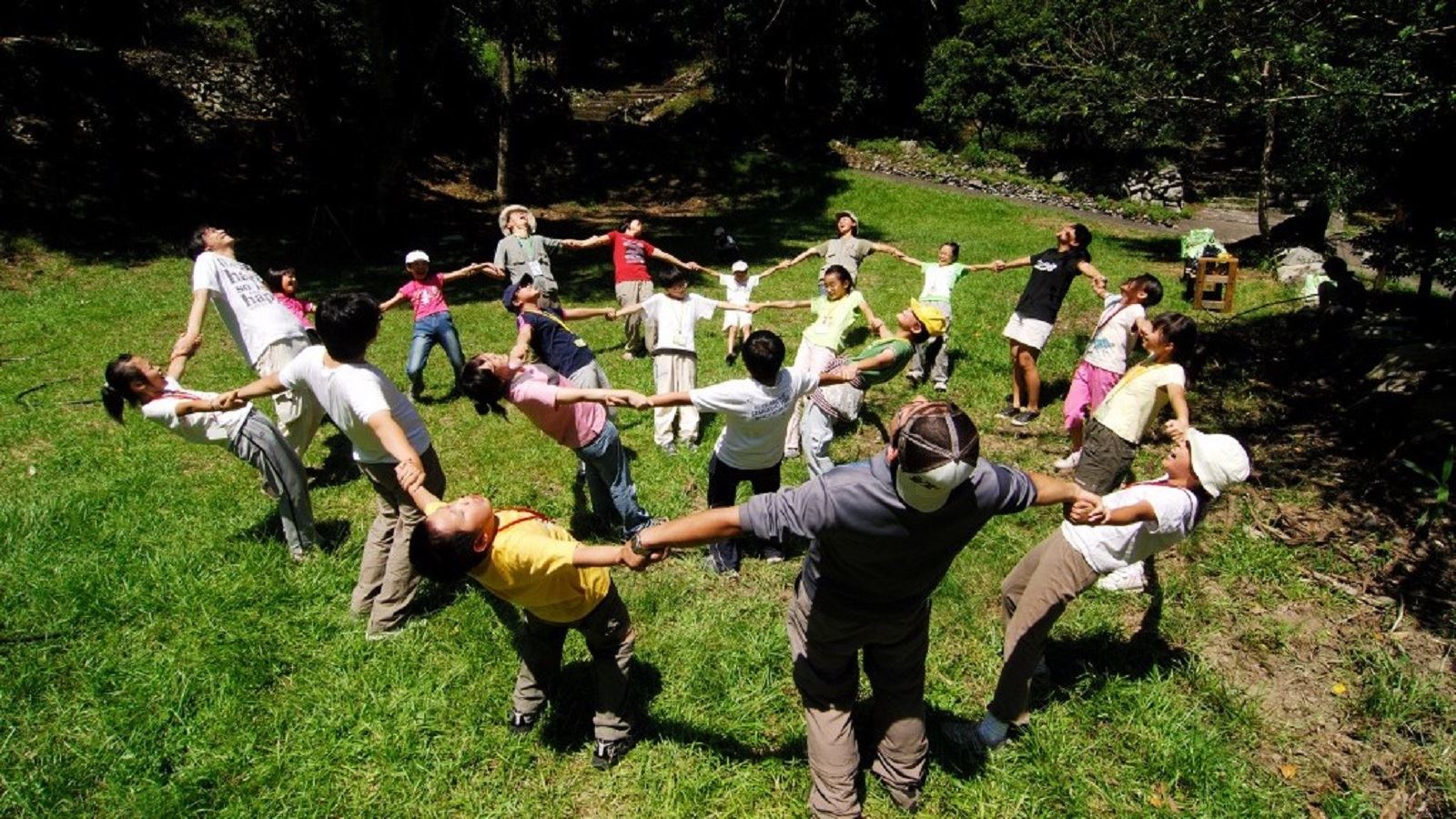
Go with your companions and don't take shortcuts.
To ensure your safety, please go with your companions, follow the indicators, do not take shortcuts or self-directed routes, and do not leave your team and walk alone.
Carry Global Positioning System and communication equipment
For hiking, please plan your trip and bring enough equipment and food with you. It is suggested that you should carry Global Positioning System (GPS) and communication equipment such as a satellite phone, mobile phone, radio or satellite positioning equipment such as Personal Locator Beacon (PLB), etc., and should carry enough batteries to ensure emergency communication.
Quickly pass dangerous areas
The road condition in the mountainous area is unstable. Please do not stay or take pictures in dangerous areas such as collapsed or falling rocks and pay attention to your own safety at any time.
It is recommended to complete the mountaineering insurance
There are certain risks in mountain activities. It is recommended that you should complete mountaineering insurance before departure. (Note: General travel insurance does not necessarily cover mountaineering accidents. Please refer to the policy details before applying for insurance. For the mountaineering insurance, please refer to the following instructions in Financial Supervisory Commission's press release and choose the appropriate insurance.)
Information on mountaineering safety
For information on mountaineering safety, mountaineering equipment, and tips for using maps, please visit the website http://goo.gl/QUnv53u. It is recommended to read the information before the trip to ensure your outdoor activities are safe.
Travel Guide

Travel Guide
Featured Landscape
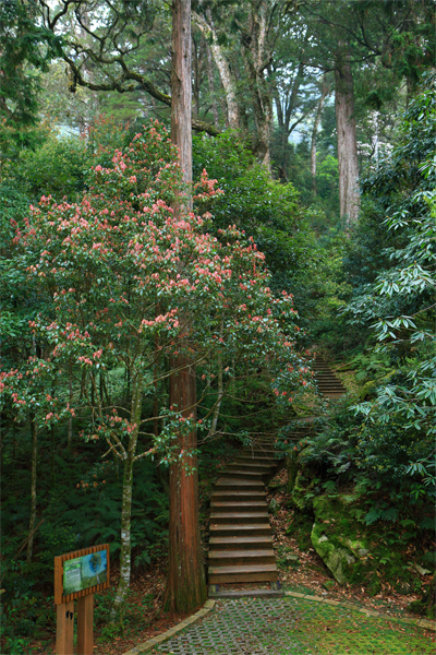
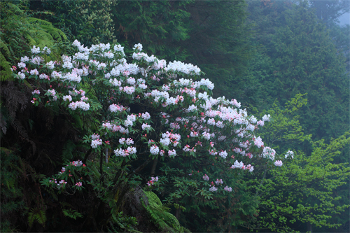
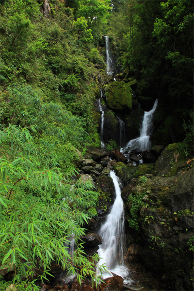
Enjoy the baptism of nature - Forest Bathing Trail
Source|吳志學
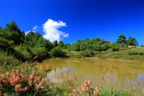
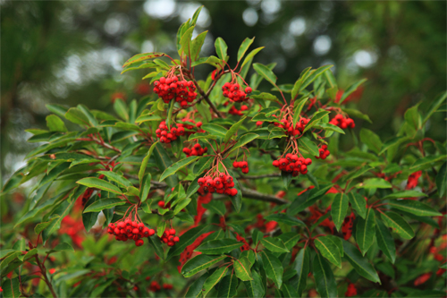
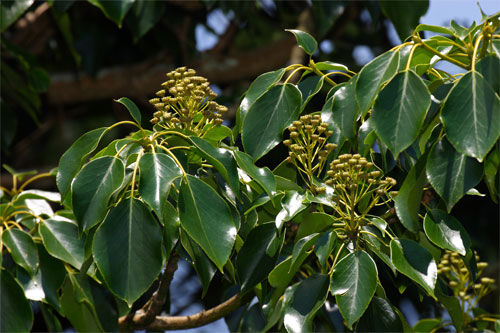
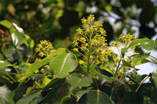
The park has rich and diverse animal and plant resources, including coniferous and broad-leaved tree species such as hemlock, Taiwan cypress, red cypress, Armand pine, Kunlan tree, Quercus serrulata, and Schima superba in the upper forest, and shrubs such as white-flowered star anise, alpine new Litsea cubeba, jade gray wood, deep mountain wild peony, and horse chestnut tree in the lower forest. Among them, the Kunlan tree is a glacial relict plant and is even more precious. The scenery has its own unique charm with the changing seasons. In spring, there are azaleas, in summer, there are alpine flowers such as lilies and foxgloves, and in autumn and winter, there are red-leaf trees such as Taiwan red maple, mountain lacquer, liquidambar formosana, and "Yushan false sand pear".
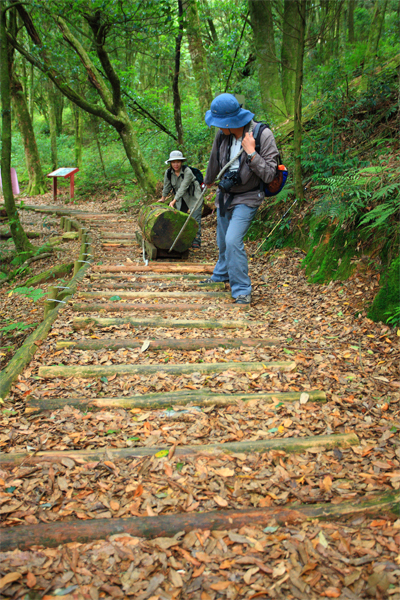
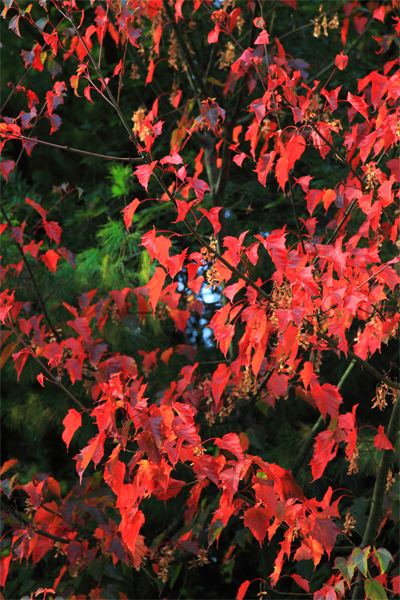
The ancient road carrying past memories - the wooden horse road
Source|吳志學
The wooden horse trail located at the foot of the mountain behind the Anmashan workstation is about 3 kilometers long and was an important road for our ancestors to transport felled trees. Following the timber transport track, there are natural original coniferous and broad-leaved forests on both sides. Many wooden bridges are built using local fallen cypress trees, and the air is filled with a strong cypress aroma. The understory is covered with Taiwan scaly ferns and rare ferns, while the valley is full of sapling ferns. In autumn, you can also enjoy the red maple leaves falling all over the ground. In the afternoon, the fog is lingering, as if walking through a mysterious forest.
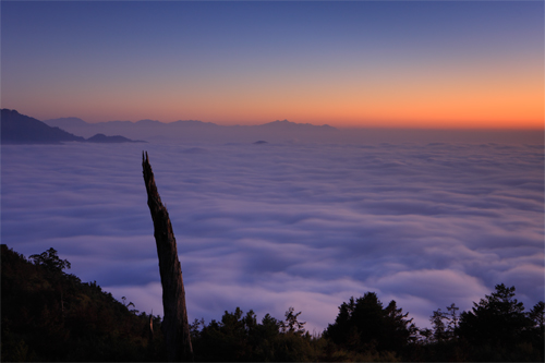
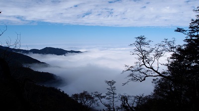
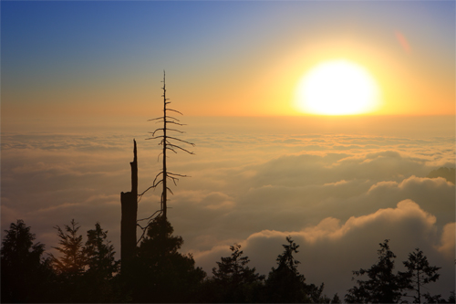
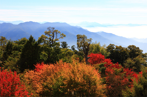
Enjoy the ever-changing scenery of the sea of clouds - Yakou Observation Deck Trail
Source|吳志學
Behind the parking lot at 48K on the forest road, there is a mountain trail leading to the "Yakou" viewing platform. Along the way, you can see lush and tall coniferous forests such as Taiwan cypress and Taiwan hemlock, as well as the lush green Yushan arrow bamboo landscape. The "pass" at the end point is the ridge from Anma Mountain, Xiaoxue Mountain to Pingshi Mountain, with an altitude of about 2,600 meters. The view is broad. Climbing up to the 13-meter-high observation deck, you can overlook Xiaoxue Mountain to the north, Jiayang Mountain and Jian Mountain to the east, the mountains behind are the Hehuan Mountain Range, and you can see Baigou Mountain and Baxian Mountain to the south. When visibility is high in the southwest, you can also see Yushan Mountain. Further northwest are Shaolai Mountain, Yuanzui Mountain, and Chuanxing Mountain. You can also enjoy the ever-changing sea of clouds or sunset views with the light and shadow. When there is sufficient moisture in winter, you will have the opportunity to see the beautiful scenery of the snow-capped mountains.
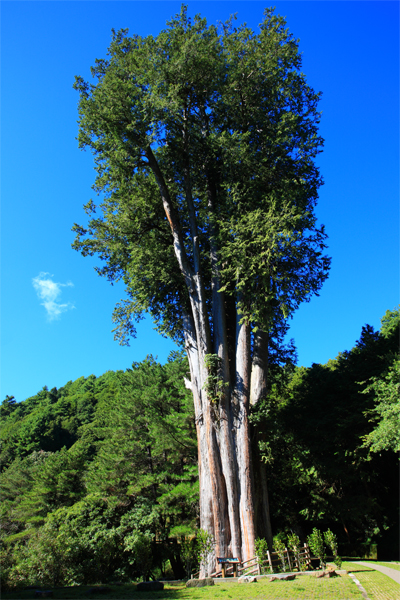
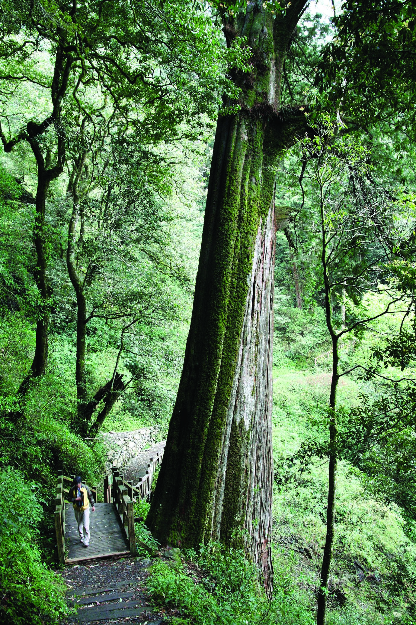
The Millennium Immortal Giant Tree Style - Snow Mountain Sacred Tree Hiking Trail
Source|吳志學
The "Tianchi" with an altitude of about 2,580 meters is located on the southern ridge of Xiaoxue Mountain. Although there are no streams flowing into it, it never dries up all year round. When the clouds are misty in the afternoon, the looming lake surface adds to the mystery. Going from Tianchi Lake to Shenmu, you will pass through a mixed forest of coniferous and broad-leaved trees such as hemlock, Chinese pine, and Taiwan azalea, and then you will see the tall and luxuriant sacred tree of the snow-capped mountains - the 1,400-year-old red cypress.
Nearby Attractions