Dahu Township, Miaoli County, Tai-an Township, Miaoli County
Mt. Manabang Summit Trail
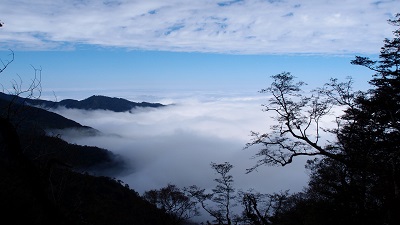
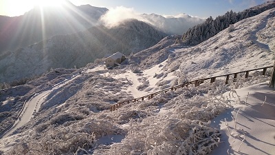
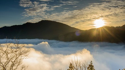
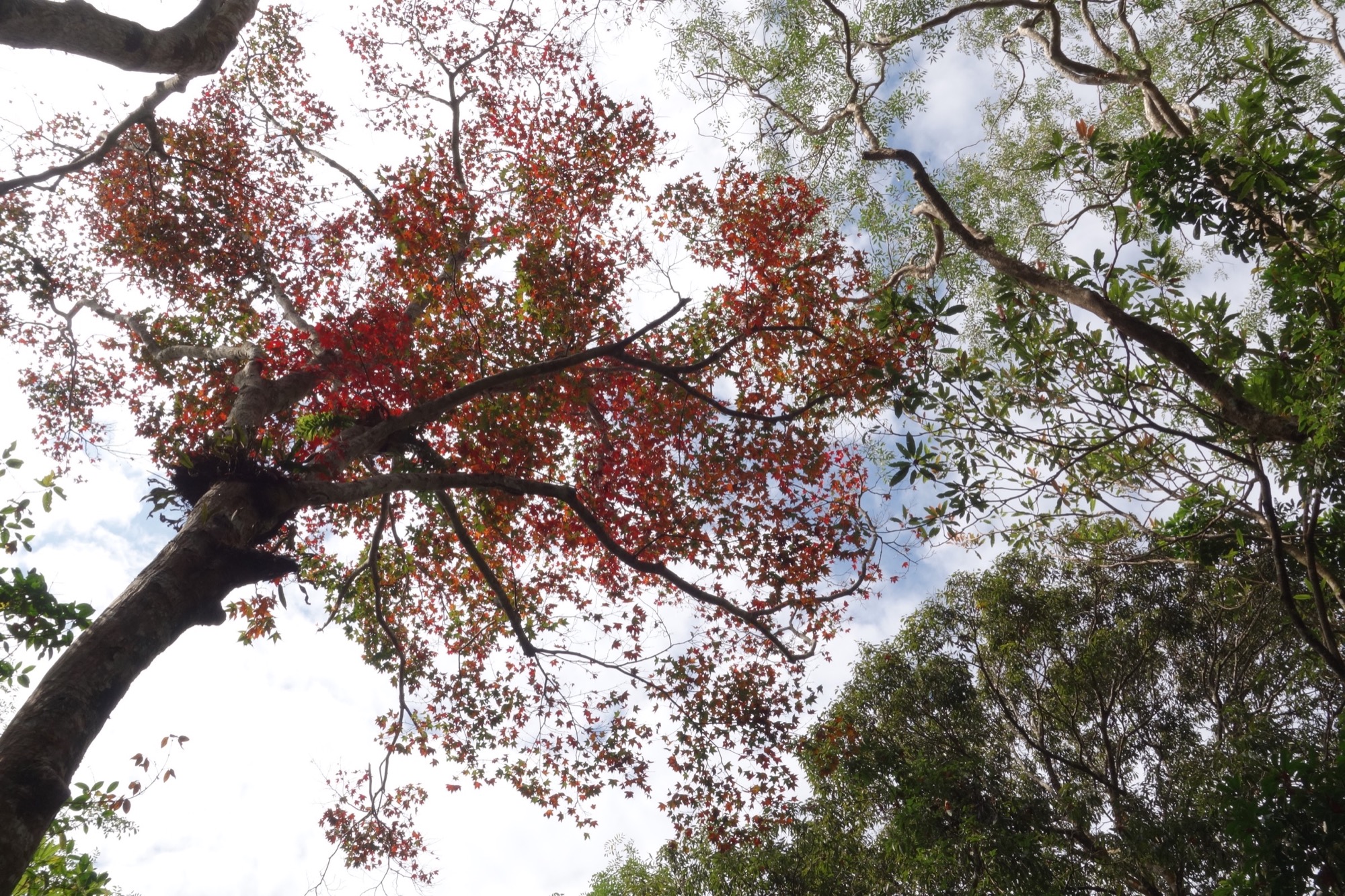
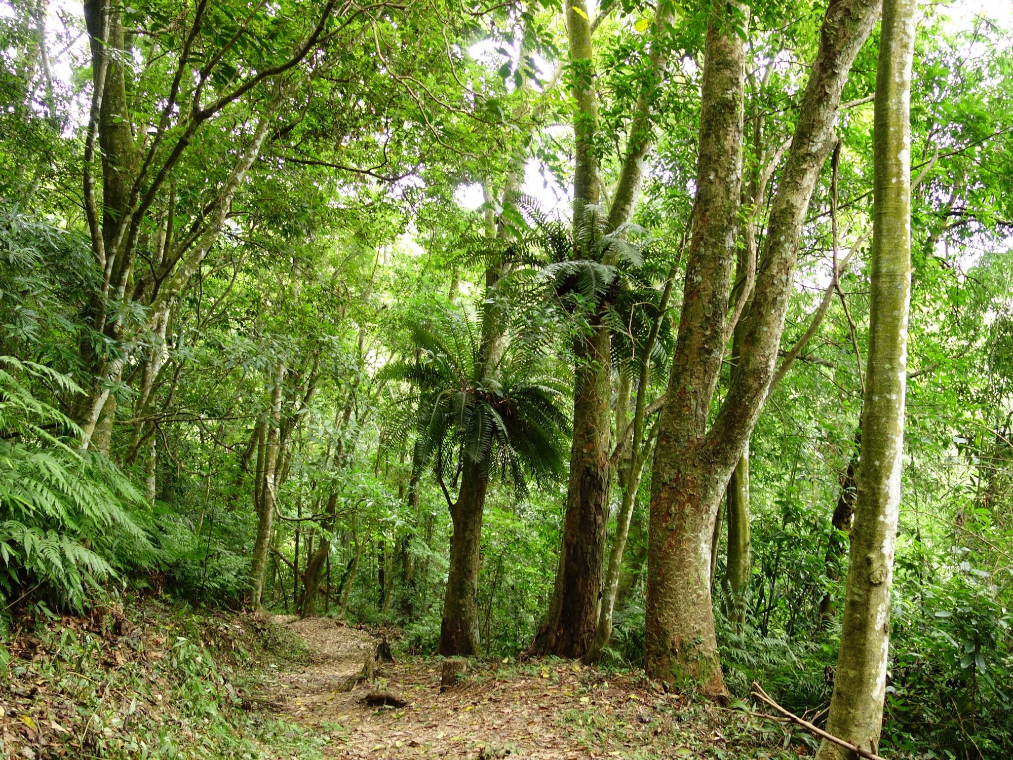
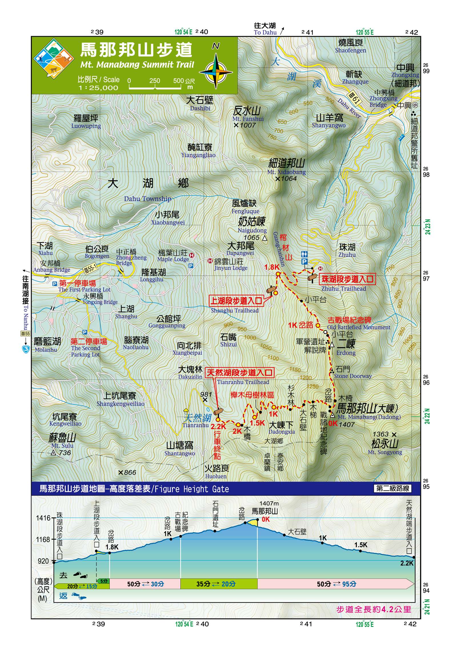
Malabang Trail used to be the mountain path taken by the people of Atayal Liyung Peynux to travel and go hunting. During the Japanese Rule, it was widened to be a Japanese police defense line. There is a monument set up to commemorate an incident in which Atayal people stood up against the Japanese. The trail passes some fir plantations and Taiwan Zelkova plantations. Dissimilar features can be seen in different seasons, including peach blossoms in spring, green bamboo in summer, red maple leaves in autumn and plum blossoms in winter. From the top of the mountain, the Daan River meandering around a number of mountains and the Holy Ridgeline between Dabajian Mountain and the snow Mountains can be seen in the distance.
05/03 Sun.
Open
22°
20° / 25°
苗栗縣 / 大湖鄉
More
Weather Forecast
|
05.04
Mon.
|
05.05
Tue.
|
05.06
Wed.
|
05.07
Thur.
|
05.08
Fri.
|
05.09
Sat.
|
05.10
Sun.
|
|
|---|---|---|---|---|---|---|---|
| Temperature |
20 ° / 25 °
|
19 ° / 22 °
|
19 ° / 28 °
|
20 ° / 29 °
|
21 ° / 30 °
|
21 ° / 27 °
|
20 ° / 26 °
|
| Feel like | 20 ° / 26 ° | 21 ° / 24 ° | 20 ° / 31 ° | 22 ° / 33 ° | 22 ° / 34 ° | 22 ° / 31 ° | 21 ° / 28 ° |
|
Probability of Precipitation |
30 % | 60 % | 20 % | - | - | - | - |
| Relative Humidity | 91 % | 98 % | 87 % | 88 % | 86 % | 89 % | 83 % |
|
Wind speed Wind direction |
3
N
|
2
NW
|
2
NW
|
2
SW
|
2
S
|
2
S
|
2
N
|
| UVI |
5
Moderate
|
3
Moderate
|
8
Very High
|
9
Very High
|
7
High
|
7
High
|
7
High
|
|
Sunrise Sunset |
|
|
|
|
|
|
|
Central Weather Bureau|Update Time:2026/05/03 17:07
Dahu Township, Miaoli County, Tai-an Township, Miaoli County
Mt. Manabang Summit Trail
Learn about the Trail
Application
Transportation
Upper Lake Trailhead/Natural Lake Trailhead
Take National Highway 1 to Miaoli Interchange, and head north on Houwen Highway (Taiwan Route 6). Take the Houlong-Wenshui East-West Expressway (Taiwan Route 72) to Wenshui. Cross the Xinwenshui Bridge (Taiwan Route 3) and head south to Dahu. Take Miaoli Township Road 55 to Linliping, and then take Miaoli Route 55-1 to Dongxing Village (there are traffic signs to Manabong Mountain for maple viewing along the way). Pass Dongxing Elementary School and follow the signs to the Shanghu Trailhead (North Route) or the Natural Lake Trailhead (South Route).
Zhuhu Trailhead
Take National Highway 1 to exit at Miaoli Interchange, and head north along Houwen Highway (Taiwan Route 6). Connect to Houlong-Wenshui East-West Expressway (Taiwan Route 72) to reach Wenshui. Cross the Xinwenshui Bridge (Taiwan Route 3) and head south to Dahu. Next to Dahu Junior High School, take Miaoli Township Road 61. After crossing the Zhongxing Bridge, turn right onto Zhuhu Farm Road. Follow the farm road for about 4 kilometers to reach the Zhuhu Trail trailhead.
-
Trail difficulty level
| Hiking Level |
|
|
|
|
|
|
|
||||||||||||||||||||||||||||||||||||||||||
|---|---|---|---|---|---|---|---|---|---|---|---|---|---|---|---|---|---|---|---|---|---|---|---|---|---|---|---|---|---|---|---|---|---|---|---|---|---|---|---|---|---|---|---|---|---|---|---|---|---|
| Target | General Public | General Public | Those who have better physical energy | Beginner mountain climber with good physical energy and map literacy. | Open to those who have good physical strength, map reading skills, and wild survival skills. | Open to well-trained mountain climbers. | Open to well-trained mountain climbers. | ||||||||||||||||||||||||||||||||||||||||||
| Elevation | Gently sloping area | In recreational areas, close to settlements or about 1,000 meters above sea level. | In recreational areas, close to settlements or between 1,000~2,000 meters above sea level. | Remote areas or between 2,000 to 3,000 meters above sea level | Remote areas, wilderness, or between 2,000 to 3,000 meters above sea level | Remote areas, wilderness, or more than 3,000 meters above sea level | Remote areas, wilderness, or more than 3,000 meters above sea level | ||||||||||||||||||||||||||||||||||||||||||
| Required Time | It takes half to one day. | It takes half to one day. | It can be done within one day. | It takes one or more days. | Overnight preparation required. | It takes up to three days. | It takes up to three days. | ||||||||||||||||||||||||||||||||||||||||||
| Equipment | Light backpacking (water and small amount of food) | Light backpacking (water and small amount of food) | Light backpacking (water and proper amount of food) | Overnight preparation required. (e.g. drinking water, food, map, warm clothing, first-aid medicine, etc.) Application for entrance permission in advance is required if there is access control. | Comprehensive Mountaineering Gear Required. (e.g. food, drinking water, cooking utensils, map, warm clothing, flashlight, sleeping bag, tent, etc.) Application for entrance permission in advance is required if there is access control. | Comprehensive Mountaineering Gear Required. (e.g. food, drinking water, cooking utensils, map, warm clothing, flashlight, sleeping bag, tent, etc.) Application for entrance permission in advance is required if there is access control. | Comprehensive Mountaineering Gear Required. (e.g. food, drinking water, cooking utensils, map, warm clothing, flashlight, sleeping bag, tent, etc.) Application for entrance permission in advance is required if there is access control. | ||||||||||||||||||||||||||||||||||||||||||
| Description | Flat hiking trails. Relatively even slopes with comprehensive facilities and smooth road surface. Accessible for handicapped assistive devices or baby strollers. | An open hiking trail with easy access. Relatively even slopes with comprehensive facilities and smooth road surface. It takes half a day or less than one day to complete. | An open hiking trail with easy access. Somewhat steep slope with some difficult sections, but has comprehensive facilities and smooth road surface. It takes less than one day to complete. | A hiking trail locates at remote area or with part of the route is in area which requires entrance permission. Application in advance is required. Part of the route is in relatively bad condition with steeper slopes, but basic facilities are provided. It takes one day or between one to three days to complete. | A hiking trail locates at remote area or with part of the route is in area which requires entrance permission. It’s located in high-altitude areas (higher than 3000 meters above sea level). The trail is relatively primitive, with steeper slopes and unstable weather conditions. Part of the route may be dangerous or difficult for climbers. It takes two to three days to complete. Lead from professionals is recommended. | A hiking trail locates at area with inconvenient traffic, and mostly with routes in area which requires entrance permission. It’s located in high-altitude areas (higher than 3000 meters above sea level). The trail is located at primitive area, with bad condition, steeper slopes, and unstable weather conditions. Many parts of the route may be dangerous or difficult for climbers. It takes three or more days to complete. Lead from professionals is recommended. | 1. Level 3, 4 or 5 trails when snow or ice accumulating 2. Informal trails, without clear subgrades or paths, belong to special routes such as original mountain trails, ancient trail relics, prospecting, or technical climbing. |
Hiking Level
Target
General Public
Elevation
Gently sloping area
Required Time
It takes half to one day.
Equipment
Light backpacking (water and small amount of food)
Description
Flat hiking trails. Relatively even slopes with comprehensive facilities and smooth road surface. Accessible for handicapped assistive devices or baby strollers.
Hiking Level
Target
General Public
Elevation
In recreational areas, close to settlements or about 1,000 meters above sea level.
Required Time
It takes half to one day.
Equipment
Light backpacking (water and small amount of food)
Description
An open hiking trail with easy access. Relatively even slopes with comprehensive facilities and smooth road surface. It takes half a day or less than one day to complete.
Hiking Level
Target
Those who have better physical energy
Elevation
In recreational areas, close to settlements or between 1,000~2,000 meters above sea level.
Required Time
It can be done within one day.
Equipment
Light backpacking (water and proper amount of food)
Description
An open hiking trail with easy access. Somewhat steep slope with some difficult sections, but has comprehensive facilities and smooth road surface. It takes less than one day to complete.
Hiking Level
Target
Beginner mountain climber with good physical energy and map literacy.
Elevation
Remote areas or between 2,000 to 3,000 meters above sea level
Required Time
It takes one or more days.
Equipment
Overnight preparation required. (e.g. drinking water, food, map, warm clothing, first-aid medicine, etc.)
Application for entrance permission in advance is required if there is access control.
Description
A hiking trail locates at remote area or with part of the route is in area which requires entrance permission. Application in advance is required. Part of the route is in relatively bad condition with steeper slopes, but basic facilities are provided. It takes one day or between one to three days to complete.
Hiking Level
Target
Open to those who have good physical strength, map reading skills, and wild survival skills.
Elevation
Remote areas, wilderness, or between 2,000 to 3,000 meters above sea level
Required Time
Overnight preparation required.
Equipment
Comprehensive Mountaineering Gear Required. (e.g. food, drinking water, cooking utensils, map, warm clothing, flashlight, sleeping bag, tent, etc.)
Application for entrance permission in advance is required if there is access control.
Description
A hiking trail locates at remote area or with part of the route is in area which requires entrance permission. It’s located in high-altitude areas (higher than 3000 meters above sea level). The trail is relatively primitive, with steeper slopes and unstable weather conditions. Part of the route may be dangerous or difficult for climbers. It takes two to three days to complete. Lead from professionals is recommended.
Hiking Level
Target
Open to well-trained mountain climbers.
Elevation
Remote areas, wilderness, or more than 3,000 meters above sea level
Required Time
It takes up to three days.
Equipment
Comprehensive Mountaineering Gear Required. (e.g. food, drinking water, cooking utensils, map, warm clothing, flashlight, sleeping bag, tent, etc.)
Application for entrance permission in advance is required if there is access control.
Description
A hiking trail locates at area with inconvenient traffic, and mostly with routes in area which requires entrance permission. It’s located in high-altitude areas (higher than 3000 meters above sea level). The trail is located at primitive area, with bad condition, steeper slopes, and unstable weather conditions. Many parts of the route may be dangerous or difficult for climbers. It takes three or more days to complete. Lead from professionals is recommended.
Hiking Level
Target
Open to well-trained mountain climbers.
Elevation
Remote areas, wilderness, or more than 3,000 meters above sea level
Required Time
It takes up to three days.
Equipment
Comprehensive Mountaineering Gear Required. (e.g. food, drinking water, cooking utensils, map, warm clothing, flashlight, sleeping bag, tent, etc.)
Application for entrance permission in advance is required if there is access control.
Description
1. Level 3, 4 or 5 trails when snow or ice accumulating
2. Informal trails, without clear subgrades or paths, belong to special routes such as original mountain trails, ancient trail relics, prospecting, or technical climbing.
Reachable by Vehicle
O:Cars , X:Microbus、Coach Bus
Mountain system
Simaheng Mountain
Administer
Hsinchu Forest Dist. Office
Elevation
800 ~ 1,406 m
Service Line
+886 35224163 #262
Altitude Difference
606 m
Huts
-
Length of the Trail
4.2 KM
Entry Permit
No
Trail type
Linear two-way
Via Nature Reserve
No
Service Line
Wooden path,Macadam road
Geologically Sensitive Area
Yes
Route planning
1 day
Debris Flow Torrents
No
Trail Track
Trail route
Trailhead / Trig
Mobile coverage
Observations (From iNaturalist)
Trailhead / Trig
Mobile coverage
Observations (From iNaturalist)
Reminders
Recommended equipment
Manabong Mountain Hiking Trail - Suggested Equipment List for One-Day Hiking Trails
Mountain Encyclopedia
Please click below to view information
Travel Guide

Travel Guide
Nearby Attractions
Fayun Temple
Fayun Temple is located on Guanyin Mountain in Dahu Township. It was built in 1913 and is one of the four major Buddhist holy sites in Taiwan. The temple has been rebuilt into a Japanese-style temple building. The garden is full of cherry blossoms and ancient trees. In front of the main hall, you can see the Miaoli mountains in the distance and overlook the Wenshui River Valley.
Zhaozhong Tower
Yimin Temple is the local faith center. It was built in the 9th year of the Tongzhi reign of the Qing Dynasty (1870) by Wu Dingxin and other settlers at that time. It is dedicated to the local braves and settlers who died during the reclamation. The Zhaozhong Tower next to it commemorates Luo Fuxing and other Hakka anti-Japanese heroes who died in the "Dahu Incident" in 1913.
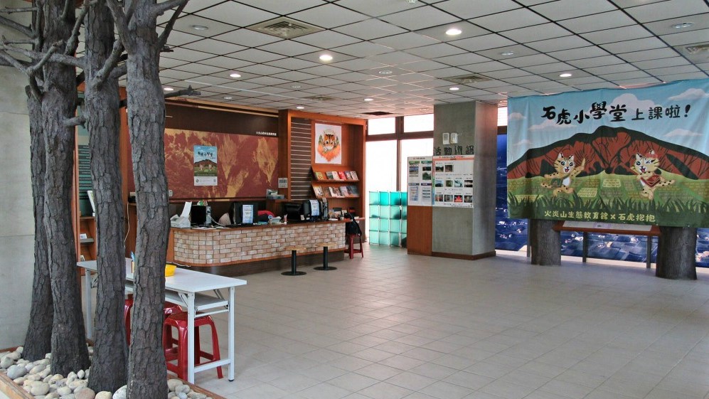
Shei-Pa National Park Wenshui Visitor Center
The area is dominated by tree-lined boulevard landscapes. There is an ecological landscape lake between the visitor center and the management office. There are interpretation trails around the lake. The south side is a wild stream environmental restoration area. The innermost part of the base is a native nursery. It is the best place for outdoor natural ecology studies and environmental education.
More
Travel Advice
There are three trailheads, two in Dongxing Village - the southern Tianranhu Trailhead, the northern Shanghu Trailhead, and the Zhuhu Trailhead in Xidaobang (Zhongxing Village) in Tai'an Township. These are less frequented. It is recommended to take the original route back and forth. Combined with the attractions near Miaoli Dahu, a 1-2 day trip can be arranged.
Nearby Attractions