Gaoshu Township, Pingtung County, Sandimen Township, Pingtung County, Maolin District, Kaohsiung City
Mt. Weiliao Trail
Weiliao Mountain is located on the border of Sandimen, Pingtung and Maolin, Kaohsiung. The first half of the trail is a country road with gentle gradient and the second half is a long and steep mountain path, a challenging hiking trail typically seen on mountains ranking in the Top 100 Lower Mountains. The summit is a secondary triangulation station, but there are many observation points. The entire trail is sheltered by the forest where the biological diversity is high. It is one of the best trails for scenery watching, ecological education and hiking.
07/16 Wed.
Open
30°
26° / 34°
屏東縣 / 高樹鄉
More
Weather Forecast
|
07.16
Today
|
07.17
Thur.
|
07.18
Fri.
|
07.19
Sat.
|
07.20
Sun.
|
07.21
Mon.
|
07.22
Tue.
|
|
|---|---|---|---|---|---|---|---|
| Temperature |
26 ° / 34 °
|
26 ° / 33 °
|
26 ° / 32 °
|
26 ° / 31 °
|
26 ° / 31 °
|
25 ° / 32 °
|
25 ° / 32 °
|
| Feel like | 30 ° / 40 ° | 31 ° / 40 ° | 30 ° / 38 ° | 31 ° / 37 ° | 30 ° / 38 ° | 29 ° / 38 ° | 29 ° / 39 ° |
|
Probability of Precipitation |
50 % | 90 % | 40 % | - | - | - | - |
| Relative Humidity | 85 % | 87 % | 87 % | 87 % | 88 % | 91 % | 90 % |
|
Wind speed Wind direction |
2
NE
|
2
NE
|
2
NE
|
2
N
|
2
N
|
2
NE
|
2
E
|
| UVI |
10
Very High
|
9
Very High
|
8
Very High
|
7
High
|
7
High
|
7
High
|
7
High
|
|
Sunrise Sunset |
|
|
|
|
|
|
|
Central Weather Bureau|Update Time:2025/07/16 05:11
Gaoshu Township, Pingtung County, Sandimen Township, Pingtung County, Maolin District, Kaohsiung City
Mt. Weiliao Trail
Learn about the Trail
Application
Transportation
National Highway no.3
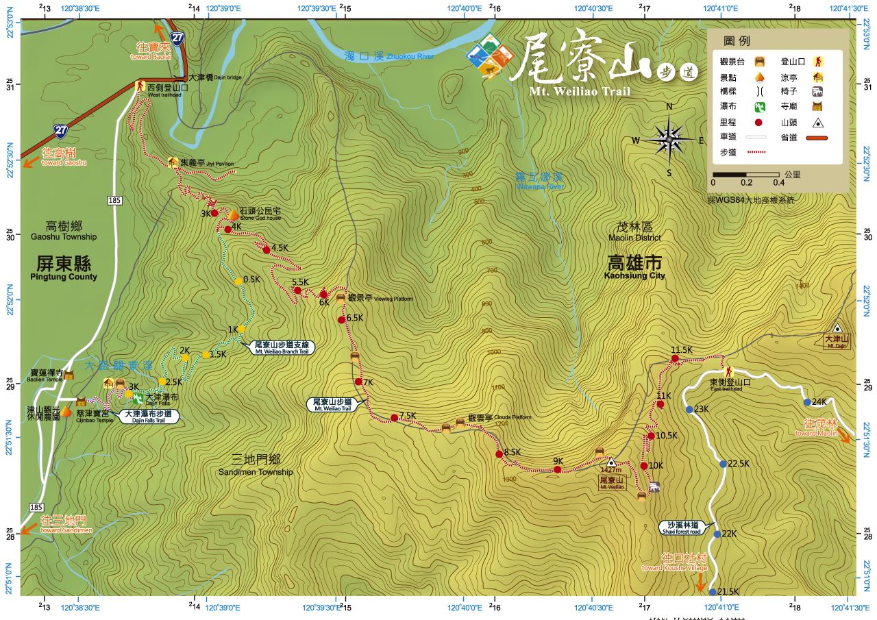
1. west hiking trail entrance, Provincial highway no.3→exit at Jiuru interchange→take a left, go along Provincial Highway no.3 toward Ligang→take a right, go along Provincial Highway to Kao Shu→Provincial Highway no.27, take a left before reaching Dajing Bridge to mountain highway (county highway no.185)
The mountainside road, Pingtung County Road no.185
2.Dajing waterfall hiking trail entrance: take Pintung County highway, mountain road to Po Lin Monastery, head west and pass enter Jinshan tourist Farm, reach Tsu Jin Bao Temple, and find the hiking trail entrance. It also leads to branches of the hiking trial.
By bus
West entrance of the hiking trail: take Pingtung Bus bound for Dajing and get off at Da jin Stop.
Trail difficulty level
| Hiking Level |
|
|
|
|
|
|
|
||||||||||||||||||||||||||||||||||||||||||
|---|---|---|---|---|---|---|---|---|---|---|---|---|---|---|---|---|---|---|---|---|---|---|---|---|---|---|---|---|---|---|---|---|---|---|---|---|---|---|---|---|---|---|---|---|---|---|---|---|---|
| Target | General Public | General Public | Those who have better physical energy | Beginner mountain climber with good physical energy and map literacy. | Open to those who have good physical strength, map reading skills, and wild survival skills. | Open to well-trained mountain climbers. | Open to well-trained mountain climbers. | ||||||||||||||||||||||||||||||||||||||||||
| Elevation | Gently sloping area | In recreational areas, close to settlements or about 1,000 meters above sea level. | In recreational areas, close to settlements or between 1,000~2,000 meters above sea level. | Remote areas or between 2,000 to 3,000 meters above sea level | Remote areas, wilderness, or between 2,000 to 3,000 meters above sea level | Remote areas, wilderness, or more than 3,000 meters above sea level | Remote areas, wilderness, or more than 3,000 meters above sea level | ||||||||||||||||||||||||||||||||||||||||||
| Required Time | It takes half to one day. | It takes half to one day. | It can be done within one day. | It takes one or more days. | Overnight preparation required. | It takes up to three days. | It takes up to three days. | ||||||||||||||||||||||||||||||||||||||||||
| Equipment | Light backpacking (water and small amount of food) | Light backpacking (water and small amount of food) | Light backpacking (water and proper amount of food) | Overnight preparation required. (e.g. drinking water, food, map, warm clothing, first-aid medicine, etc.) Application for entrance permission in advance is required if there is access control. | Comprehensive Mountaineering Gear Required. (e.g. food, drinking water, cooking utensils, map, warm clothing, flashlight, sleeping bag, tent, etc.) Application for entrance permission in advance is required if there is access control. | Comprehensive Mountaineering Gear Required. (e.g. food, drinking water, cooking utensils, map, warm clothing, flashlight, sleeping bag, tent, etc.) Application for entrance permission in advance is required if there is access control. | Comprehensive Mountaineering Gear Required. (e.g. food, drinking water, cooking utensils, map, warm clothing, flashlight, sleeping bag, tent, etc.) Application for entrance permission in advance is required if there is access control. | ||||||||||||||||||||||||||||||||||||||||||
| Description | Flat hiking trails. Relatively even slopes with comprehensive facilities and smooth road surface. Accessible for handicapped assistive devices or baby strollers. | An open hiking trail with easy access. Relatively even slopes with comprehensive facilities and smooth road surface. It takes half a day or less than one day to complete. | An open hiking trail with easy access. Somewhat steep slope with some difficult sections, but has comprehensive facilities and smooth road surface. It takes less than one day to complete. | A hiking trail locates at remote area or with part of the route is in area which requires entrance permission. Application in advance is required. Part of the route is in relatively bad condition with steeper slopes, but basic facilities are provided. It takes one day or between one to three days to complete. | A hiking trail locates at remote area or with part of the route is in area which requires entrance permission. It’s located in high-altitude areas (higher than 3000 meters above sea level). The trail is relatively primitive, with steeper slopes and unstable weather conditions. Part of the route may be dangerous or difficult for climbers. It takes two to three days to complete. Lead from professionals is recommended. | A hiking trail locates at area with inconvenient traffic, and mostly with routes in area which requires entrance permission. It’s located in high-altitude areas (higher than 3000 meters above sea level). The trail is located at primitive area, with bad condition, steeper slopes, and unstable weather conditions. Many parts of the route may be dangerous or difficult for climbers. It takes three or more days to complete. Lead from professionals is recommended. | 1. Level 3, 4 or 5 trails when snow or ice accumulating 2. Informal trails, without clear subgrades or paths, belong to special routes such as original mountain trails, ancient trail relics, prospecting, or technical climbing. |
Hiking Level
Target
General Public
Elevation
Gently sloping area
Required Time
It takes half to one day.
Equipment
Light backpacking (water and small amount of food)
Description
Flat hiking trails. Relatively even slopes with comprehensive facilities and smooth road surface. Accessible for handicapped assistive devices or baby strollers.
Hiking Level
Target
General Public
Elevation
In recreational areas, close to settlements or about 1,000 meters above sea level.
Required Time
It takes half to one day.
Equipment
Light backpacking (water and small amount of food)
Description
An open hiking trail with easy access. Relatively even slopes with comprehensive facilities and smooth road surface. It takes half a day or less than one day to complete.
Hiking Level
Target
Those who have better physical energy
Elevation
In recreational areas, close to settlements or between 1,000~2,000 meters above sea level.
Required Time
It can be done within one day.
Equipment
Light backpacking (water and proper amount of food)
Description
An open hiking trail with easy access. Somewhat steep slope with some difficult sections, but has comprehensive facilities and smooth road surface. It takes less than one day to complete.
Hiking Level
Target
Beginner mountain climber with good physical energy and map literacy.
Elevation
Remote areas or between 2,000 to 3,000 meters above sea level
Required Time
It takes one or more days.
Equipment
Overnight preparation required. (e.g. drinking water, food, map, warm clothing, first-aid medicine, etc.)
Application for entrance permission in advance is required if there is access control.
Description
A hiking trail locates at remote area or with part of the route is in area which requires entrance permission. Application in advance is required. Part of the route is in relatively bad condition with steeper slopes, but basic facilities are provided. It takes one day or between one to three days to complete.
Hiking Level
Target
Open to those who have good physical strength, map reading skills, and wild survival skills.
Elevation
Remote areas, wilderness, or between 2,000 to 3,000 meters above sea level
Required Time
Overnight preparation required.
Equipment
Comprehensive Mountaineering Gear Required. (e.g. food, drinking water, cooking utensils, map, warm clothing, flashlight, sleeping bag, tent, etc.)
Application for entrance permission in advance is required if there is access control.
Description
A hiking trail locates at remote area or with part of the route is in area which requires entrance permission. It’s located in high-altitude areas (higher than 3000 meters above sea level). The trail is relatively primitive, with steeper slopes and unstable weather conditions. Part of the route may be dangerous or difficult for climbers. It takes two to three days to complete. Lead from professionals is recommended.
Hiking Level
Target
Open to well-trained mountain climbers.
Elevation
Remote areas, wilderness, or more than 3,000 meters above sea level
Required Time
It takes up to three days.
Equipment
Comprehensive Mountaineering Gear Required. (e.g. food, drinking water, cooking utensils, map, warm clothing, flashlight, sleeping bag, tent, etc.)
Application for entrance permission in advance is required if there is access control.
Description
A hiking trail locates at area with inconvenient traffic, and mostly with routes in area which requires entrance permission. It’s located in high-altitude areas (higher than 3000 meters above sea level). The trail is located at primitive area, with bad condition, steeper slopes, and unstable weather conditions. Many parts of the route may be dangerous or difficult for climbers. It takes three or more days to complete. Lead from professionals is recommended.
Hiking Level
Target
Open to well-trained mountain climbers.
Elevation
Remote areas, wilderness, or more than 3,000 meters above sea level
Required Time
It takes up to three days.
Equipment
Comprehensive Mountaineering Gear Required. (e.g. food, drinking water, cooking utensils, map, warm clothing, flashlight, sleeping bag, tent, etc.)
Application for entrance permission in advance is required if there is access control.
Description
1. Level 3, 4 or 5 trails when snow or ice accumulating
2. Informal trails, without clear subgrades or paths, belong to special routes such as original mountain trails, ancient trail relics, prospecting, or technical climbing.
Reachable by Vehicle
僅大津段可進入中型與大型遊覽車
Mountain system
Central Mountain Range
Administer
Pingtung Forest Dist. Office
Elevation
200 ~ 1,430 m
Service Line
08-7882647
Altitude Difference
1,230 m
Huts
-
Length of the Trail
15 KM
Entry Permit
是
Trail type
Linear two-way
Via Nature Reserve
No
Service Line
Industrial road,Mountain trail
Geologically Sensitive Area
Yes
Route planning
1 day
Debris Flow Torrents
Yes
Trail Track
Trail route
Trailhead / Trig
Mobile coverage
Observations (From iNaturalist)
Trailhead / Trig
Mobile coverage
Observations (From iNaturalist)
Reminders
Go with your companions and don't take shortcuts.
To ensure your safety, please go with your companions, follow the indicators, do not take shortcuts or self-directed routes, and do not leave your team and walk alone.
Carry Global Positioning System and communication equipment
For hiking, please plan your trip and bring enough equipment and food with you. It is suggested that you should carry Global Positioning System (GPS) and communication equipment such as a satellite phone, mobile phone, radio or satellite positioning equipment such as Personal Locator Beacon (PLB), etc., and should carry enough batteries to ensure emergency communication.
Quickly pass dangerous areas
The road condition in the mountainous area is unstable. Please do not stay or take pictures in dangerous areas such as collapsed or falling rocks and pay attention to your own safety at any time.
It is recommended to complete the mountaineering insurance
There are certain risks in mountain activities. It is recommended that you should complete mountaineering insurance before departure. (Note: General travel insurance does not necessarily cover mountaineering accidents. Please refer to the policy details before applying for insurance. For the mountaineering insurance, please refer to the following instructions in Financial Supervisory Commission's press release and choose the appropriate insurance.)
Information on mountaineering safety
For information on mountaineering safety, mountaineering equipment, and tips for using maps, please visit the website http://goo.gl/QUnv135u. It is recommended to read the information before the trip to ensure your outdoor activities are safe.
Travel Guide

Travel Guide
Featured Landscape
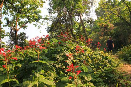
The landscape is varied and each has its own style
Source|湯谷明
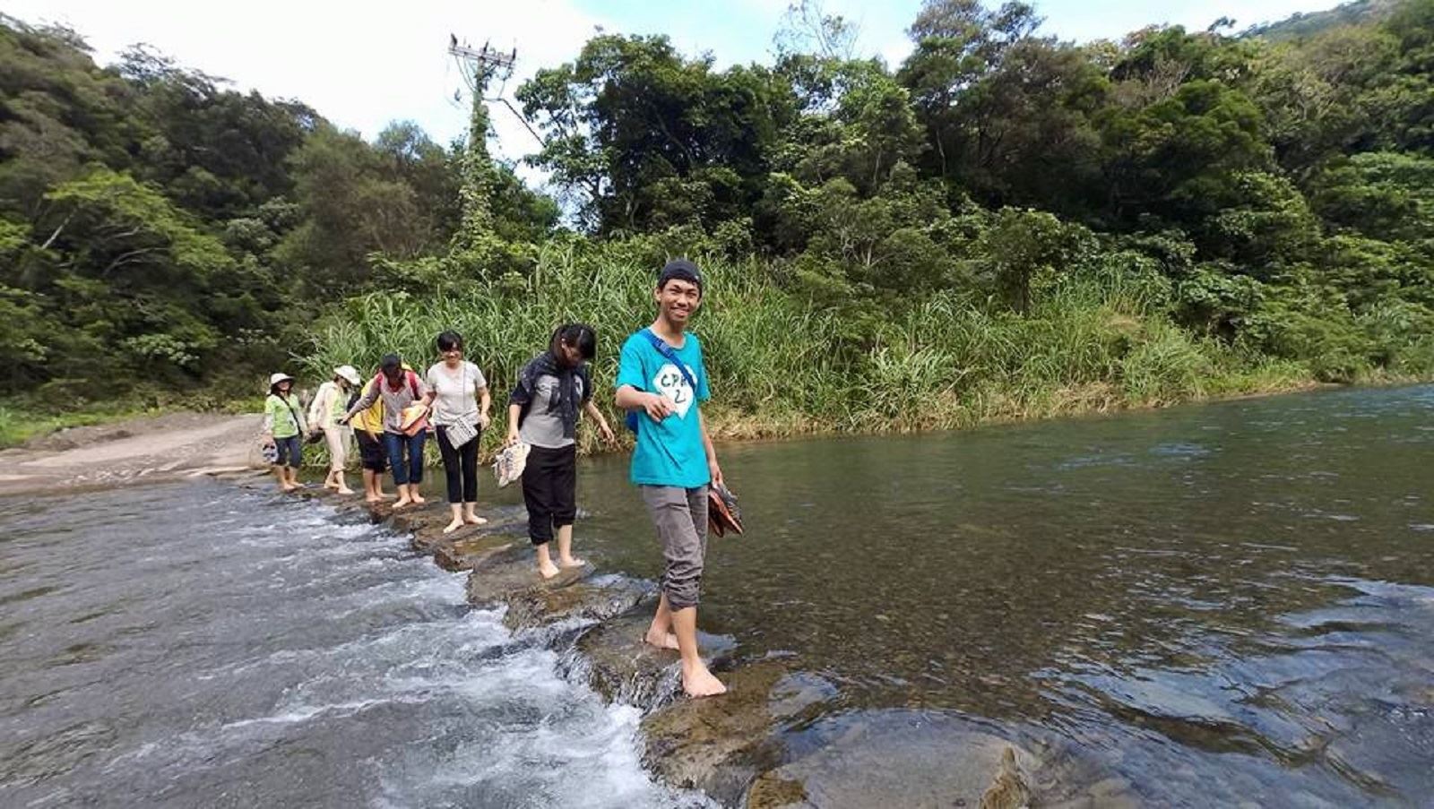
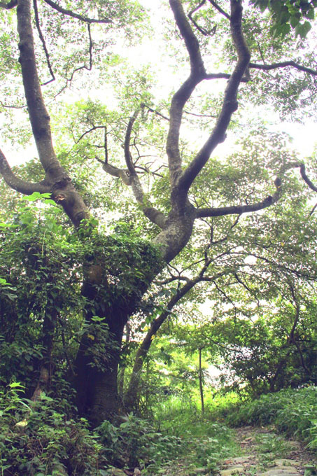
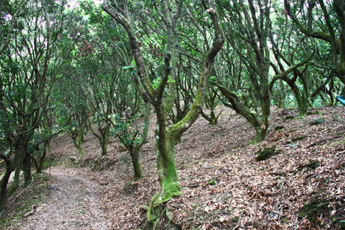
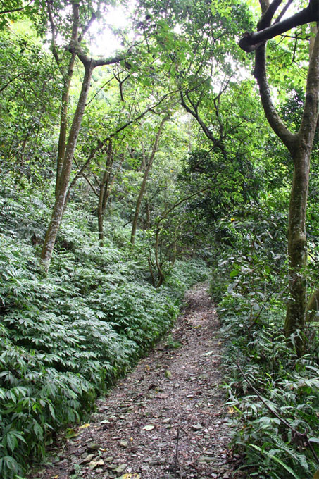
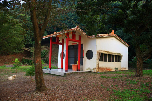
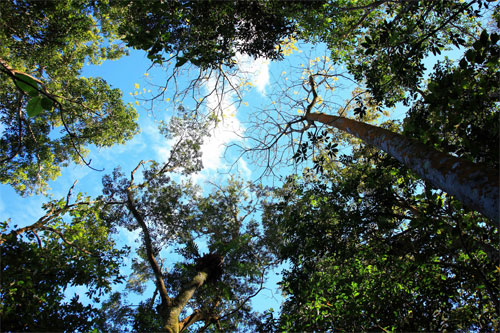
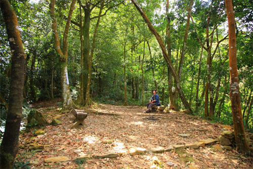
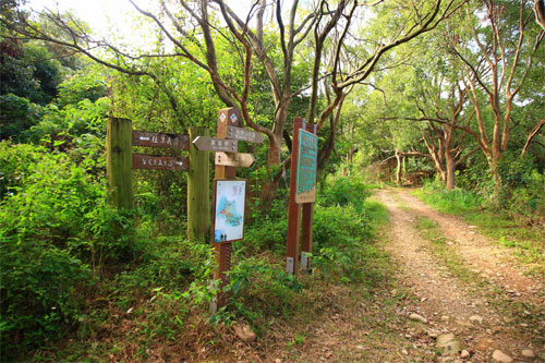
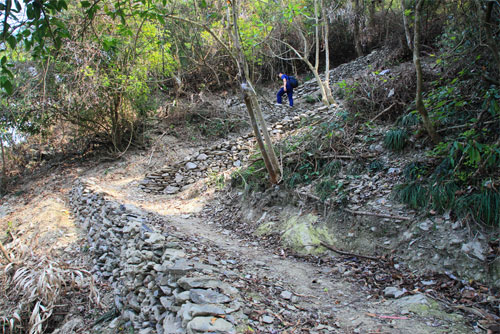
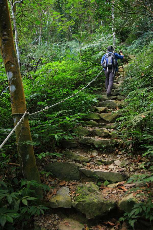
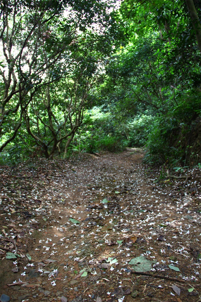
From the entrance of the Dajin Bridge, follow the zigzag trail upwards. The front section is an industrial road with mostly acacia trees and abandoned lychee orchards. When the tung trees bloom in April and May, the white flowers fall on the mountain path like snowflakes, forming a romantic white carpet. When the acacia trees bloom in June, the bright yellow flowers like small powder puffs dot the mountaintops, which is very beautiful. After about 4K, the trail turns into a mountain path, and the landscape changes into a low-altitude broad-leaved forest with several tall mountain jute trees standing in between, as well as clumps of thorny bamboo and hemp bamboo. Sometimes you can even meet the owners of the mountain patrolling the mountains and picking bamboo shoots.
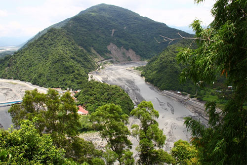
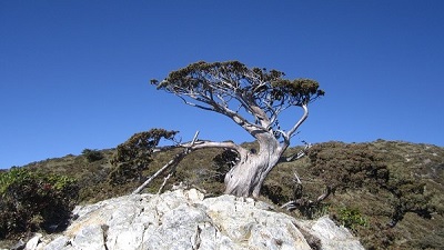
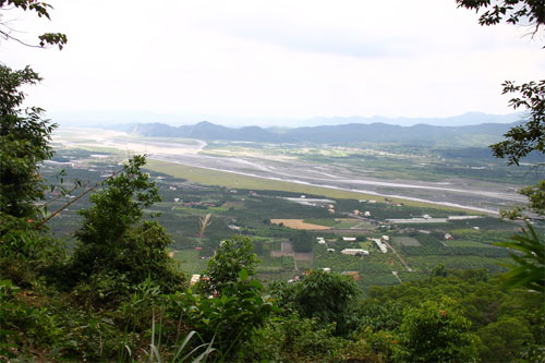
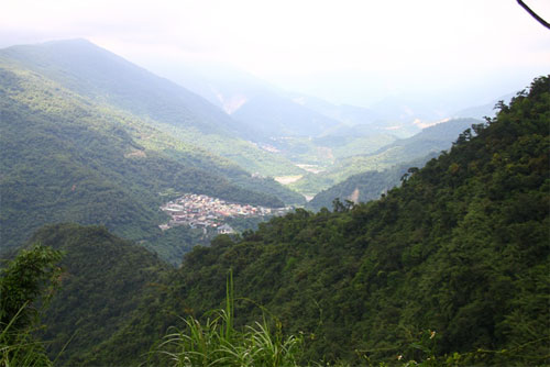
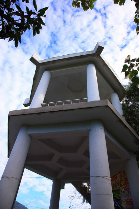
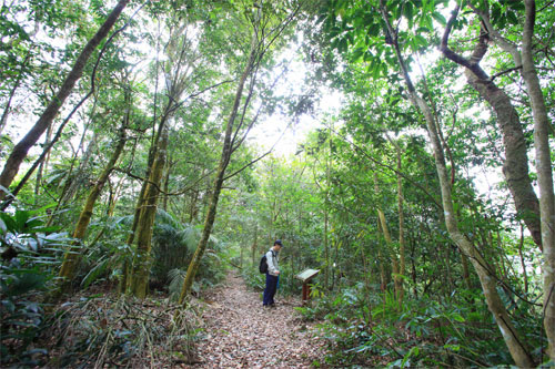
Climb high and see the mountains and rivers
Source|湯谷明
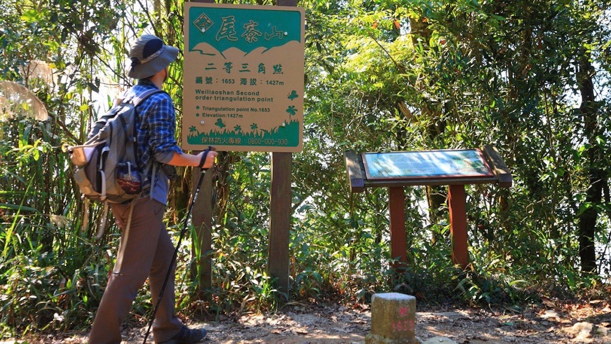
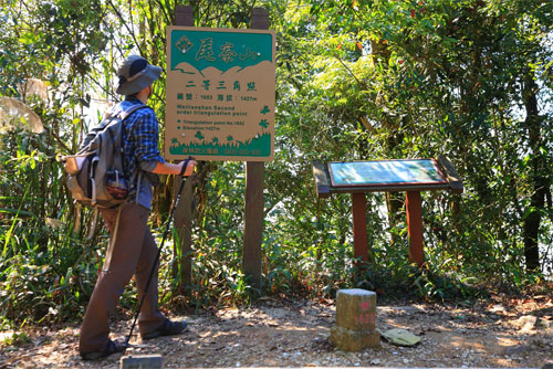
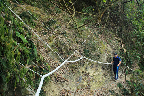
As the trail climbs, the view gradually expands. Jiyi Pavilion, which is only over 300 meters above sea level, has a good view. You can see the Laonong River and Zhuokou River converge under the Dajin Bridge to form a U-shaped river meander terrain, and Zhenwo Mountain rises from the ground at the turning point. Guanyuntai, which is 1,150 meters above sea level, is often shrouded in fog, but when the weather is clear, you can see the Maolin, Wanshan and Dona and other aboriginal tribes in the distance. If you want to continue climbing the triangulation point at an altitude of 1,427 meters, you must pass a long and steep slope with a higher difficulty level with ropes. There is a sign on the triangulation point that reads "The higher the mountain, the taller the people; the longer the water, the longer the feet", which inspires the ambitions of climbers.
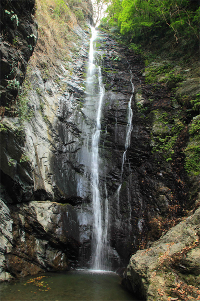
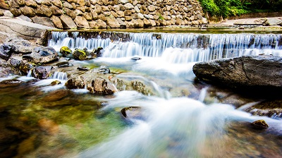
The waterfall is magnificent
Source|謝宗宇
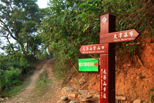
Dajin Waterfall is also known as Awu Waterfall, Weiliao Waterfall and Xinfeng Waterfall. There are green trees along the way, which is suitable for hiking. The waterfall is about 20 meters high. The stream rushes down from the steep rock wall with a magnificent momentum. It is divided into five layers. Most tourists only go to the second layer of the main waterfall because the third to fifth layers of waterfalls are located in the deep forest and are not easy to reach. The geology belongs to the Lushan Formation, which is a third sub-metamorphic rock and a Miocene stratum.
Nearby Attractions